Neukölln (locality)
| Neukölln | |
|---|---|
| Quarter of Berlin | |
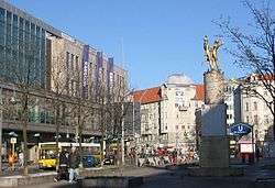 Hermannplatz | |
 Neukölln Location of Neukölln in Neukölln district and Berlin 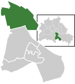 | |
| Coordinates: 52°28′53″N 13°26′07″E / 52.48139°N 13.43528°ECoordinates: 52°28′53″N 13°26′07″E / 52.48139°N 13.43528°E | |
| Country | Germany |
| State | Berlin |
| City | Berlin |
| Borough | Neukölln |
| Founded | 1360 |
| Area | |
| • Total | 11.7 km2 (4.5 sq mi) |
| Elevation | 52 m (171 ft) |
| Population (2009-06-30) | |
| • Total | 167,248 |
| • Density | 14,000/km2 (37,000/sq mi) |
| Time zone | CET/CEST (UTC+1/+2) |
| Postal codes | (nr. 0801) 12043, 12045, 12047, 12049, 12051, 12053, 12055, 12057, 12059 |
| Vehicle registration | B |
Neukölln is an inner-city locality (Ortsteil) of Berlin in the homonymous borough (Bezirk) of Neukölln, including the historic village of Rixdorf and numerous Gründerzeit apartment blocks. The Ortsteil is densely settled with a population of 154,127 inhabitants (2009) and is the most populated one of Berlin. It was characterized by a relatively high percentage of immigrants, especially of Turkish and Russian descent. Since the turn of the millennium an influx of students, creatives and western immigrants has led to gentrification.
Geography
Location
The locality is situated in the north of the Neukölln borough, adjacent to Kreuzberg (in Friedrichshain-Kreuzberg) at the Landwehrkanal. It also borders with Alt-Treptow, Plänterwald and Baumschulenweg (all part of Treptow-Köpenick) in the east and Tempelhof (in Tempelhof-Schöneberg) in the west, separated by the vast field of the former Tempelhof Airport. In the south, the Stadtring motorway forms the border with the Britz locality.
The Sonnenallee, connecting Neukölln at Hermannplatz with Baumschulenweg in former East Berlin was the site of a border crossing of the Berlin Wall, perpetuated by the 1999 Sonnenallee comedy film.
Subdivision
Neukölln counts 3 zones (Ortslagen):
- Böhmisch-Rixdorf
- Köllnische Heide
- Rixdorf
History
When first mentioned in 1360 the village south-east of Berlin, around the present-day Richardplatz, was called Richardsdorf and owned by the Order of St. John; hence the coat of arms of the current city borough bears the Maltese cross. It may have been the site of a former stronghold erected by the dissolved Knights Templar at neighbouring Tempelhof. In 1737, King Frederick William I of Prussia allowed about 350 Moravian Protestants expelled from Bohemia to settle in the area, then called Rixdorf. They built their own church and houses off the village centre along the road to Berlin, today called Richardstraße. This new Bohemian village (Böhmisch Rixdorf) was granted its own constitution in 1797.
In the course of industrialization in the 19th century a network of new streets was laid out in the Hobrecht-Plan in an area that came to be known architecturally as the Wilhelmine Ring. In 1863 a Turkish cemetery was laid out north of Rixdorf, the successor of a smaller burial ground in Kreuzberg established in 1798 for the Turkish members of the Prussian Army. It contains the mortal remains of the Ottoman ambassador Giritli Ali Aziz Efendi, the exiled Grand Vizier Mehmed Talat and Bahattin Şakir.
When both parts of the village were reunited in 1874, the place had 8,000 inhabitants, growing to 15,000 the next year. On May 1, 1899 Rixdorf, then the largest village of Prussia, received the status of an independent city and had become notorious for its taverns and amusement sites. In 1912, the local authorities tried to get rid of this reputation by assuming the current name derived from the Old Cölln part of medieval Berlin – an attempt that ultimately failed. Nevertheless, it was during this time, when the architect Reinhold Kiehl was called on by the local council to upgrade the city's infrastructure. This has led to some of the areas most iconic buildings being erected, such as the Rathaus Neukölln ('City Hall') or the Stadtbad Neukölln ('Public Bath').[1] Neukölln's independence ended in 1920 when it was incorporated into Greater Berlin. From 1945 to 1990, it was part of the American sector of West Berlin.
Gentrification
A trend is the rapid gentrification of certain neighborhoods within Neukölln. There has been an influx of students, creatives and other young professionals of mostly Western origin avoiding higher rents charged in other parts of Berlin. This has caused a knock on effect of rents to rise in some parts of Neukölln.[2] Northern Neukölln, just to the south of the Kreuzberg area has become informally referred to as "Kreuzkölln" as the area becomes increasingly fashionable.[3]
Public transport
The locality is served by three operational sections of urban rail.
- U7: Rathaus Spandau ↔ Rudow (running North West ↔ South East)
- U8: Wittenau ↔ Hermannstraße (running North ↔ South)
Part of each of the following S-Bahn routes share an East ↔ West running section of Ringbahn track through the locality:
- S41[4]/S42:[5] Südkreuz → Gesundbrunnen → Südkreuz (clockwise ↔ anti clockwise circular)
- S45:[6] Südkreuz ↔ Berlin Schönefeld Flughafen (only from Monday till Friday). An extension of the S45 is projected to run beyond the current terminus at Schönefeld Airport to the under construction Berlin Brandenburg Airport.[7]
- S46:[8] Westend ↔ Königs Wusterhausen
- S47:[9] Spindlersfeld ↔ Hermannstraße
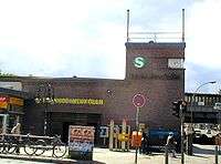
Among the numerous rail stations in the locality three act as interchanges:
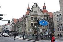
- Hermannplatz – U7 / U8
- Hermannstraße – U8 / S-Bahn
- Berlin-Neukölln – U7 / S-bahn
Main sights
- Rixdorf village church, consecrated in 1481, adopted by the Moravian Protestants in 1737, officially called Bethlehem Church since 1912.
- Şehitlik Mosque, on the Turkish cemetery, finished in 2005 by the Turkish-Islamic Union for Religious Affairs (DİTİB).
- Neuköllner Oper: Opera house that hosts a wide range of performances including musicals, baroque opera, operetta, or experimental music theatre. Famous for its aim to bring elitist culture to a wider audience.[10]
People who live or lived in Neukölln
.jpg)
- Sebastian Blomberg (born 1972), actor
- Ursula Goetze (1916–1943), resistance fighter
- Heinz Chapel (1913–1941), politician (KPD) and resistance fighter
- Kurt Krömer (born 1974), presenter, actor and entertainer
- Will Meisel (1897–1967), composer and publisher
- Werner Seelenbinder (1904–1944), wrestler, politician (KPD) and resistance fighter
- Katharina Szelinski-Singer (1918–2010), sculptor
- Emil Wutzky (1871–1963), trade unionist and local politician (SPD)
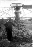
- Engelbert Zaschka (1895–1955), inventor and helicopter pioneer
Photo gallery
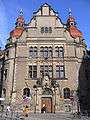 Country Court
 City hall
_Buddy_B%C3%A4r.jpg) Buddy Bear Neukölln in front of the City hall
Buddy Bear Neukölln in front of the City hall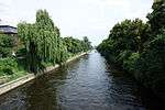 Landwehrkanal
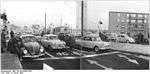 Border crossing at Sonnenallee, 1964
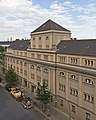 Stadtbad Neukölln
International relations
- Berlin Neukölln is a pilot city of the Council of Europe and the European Commission Intercultural Cities programme.[11]
Notes and references
- ↑ Krawczynski, Wolfgang. Architekt Reinhold Kiehl, Stadtbaurat in Rixdorf bei Berlin: Biographie, Werkverzeichnis, Beiträge : Jubiläumsbeitrag zur 750-Jahr-Feier Berlin. 1987
- ↑ http://www.spiegel.de/international/germany/neukoelln-nasties-foreigners-feel-accused-in-berlin-gentrification-row-a-750297.html
- ↑ "Sagt endlich Kreuzkölln!" 12 April 2016 Der Tagesspiegel
- ↑ S41 "Bahnhofs- und Linieninformationssystem" s-bahn-berlin.de accessed 19 March 2018
- ↑ S42 "Bahnhofs- und Linieninformationssystem" s-bahn-berlin.de accessed 19 March 2018
- ↑ S45 "Bahnhofs- und Linieninformationssystem" s-bahn-berlin.de accessed 91 march 2018
- ↑ "2020 vision for Berlin's long-overdue Brandenburg Airport" Travel weekly, 9 January 2018
- ↑ S45 "Bahnhofs- und Linieninformationssystem" s-bahn-berlin.de accessed 19 March 2018
- ↑ S47 "Bahnhofs- und Linieninformationssystem" s-bahn-berlin.de accessed 19 March 2018
- ↑ Berlin Guide – Neukölln City Getaway Guide – Berlin
- ↑ Council of Europe (2010). "Projekt Intercultural Cities – Berlin.de". berlin.de. Archived from the original on 30 May 2008. Retrieved 22 May 2011.
External links
![]()
| |