Riverside, Tasmania
| Riverside Launceston, Tasmania | |||||||||||||||
|---|---|---|---|---|---|---|---|---|---|---|---|---|---|---|---|
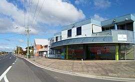 Commercial buildings and St David's Church on the corner of Ecclestone Road, Riverside | |||||||||||||||
| Population | 6,472 (2016 census)[1] | ||||||||||||||
| Postcode(s) | 7250 | ||||||||||||||
| Location | 4 km (2 mi) from Launceston, Tasmania | ||||||||||||||
| LGA(s) | West Tamar Council | ||||||||||||||
| State electorate(s) | Bass | ||||||||||||||
| Federal Division(s) | Bass | ||||||||||||||
| |||||||||||||||
Coordinates: 41°25′12″S 147°06′11″E / 41.420°S 147.103°E
Riverside is a residential suburb 4 kilometres north-west of the central business district of Launceston, Tasmania's second largest city. The West Tamar Highway runs through the suburb, adjoining Riverside to the West Tamar, which includes small towns: Beaconsfield, George Town and Beauty Point. Riverside is part of the West Tamar Council local government area. The suburb is now Launceston's largest by population, narrowly ahead of Kings Meadows. The main shopping centre opened in the 1960s and includes: a Woolworths supermarket, a Banjos bakery, a pharmacist and several retail shops.[2]
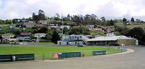
There are several schools (Riverside Primary School, Riverside High School, Launceston Christian School and St Anthony's) as well as an Aussie rules football ground named Windsor Park which is home to the Launceston Football Club, a soccer ground which is home to Riverside Olympic, the park also includes a cricket ground for senior players and also a junior ground used mainly by under 12 and under 14 sides, all along the course of the highway. Less than a 1 km further north there is a small complex containing a few shops including Joes IGA supermarket and St David's Church. Over the road is a restaurant, pub and bottle shop, as well as the 3.5 star Best Western Riverside motel.
Though mostly built in the 1960s, Riverside contains a wide range of buildings, with older brick and weatherboard style homes prominent along the West Tamar Highway and area's closer to the city, many of which being either Edwardian or Art Deco in style, while more modern homes are located in the western and northern areas. Few buildings in Riverside date from the 1800s, though the notable exception being Cormiston House, a former estate house from the mid-1800s, located on a large property at the northern extremity of Riverside.
The western half of Riverside, accessed by Pomona Road, was built in the 1950s as the hydro-electric village of Marrawaylee to serve the construction of the Trevallyn Power Station. Now known as West Riverside, this minor suburb contains a single shop, the St Francis Church as well as the old hydro lodge, now modified into a private residence. The northwestern region of West Riverside has recently been the site of Riverside's most rapid urban growth, with new suburbs now connected onto Pomona Road North, Guildford Road, Tamar Rise and Balmoral Avenue.
References
- ↑ Australian Bureau of Statistics (27 June 2017). "Riverside (State Suburb)". 2016 Census QuickStats. Retrieved 2017-12-06.

- ↑ "Riverside Shopping Centre, Riverside, TAS". Macquarie. Archived from the original on August 7, 2008. Retrieved 2009-02-25.
| City of Launceston | |
|---|---|
| Meander Valley Council | |
| West Tamar Council | |
| Minor and abolished suburbs |
|