River Piddle
| River Piddle | |
| River Trent | |
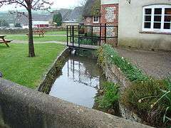 The River Piddle at Piddlehinton | |
| Country | England |
|---|---|
| County | Dorset |
| Districts | West Dorset, Purbeck |
| Tributaries | |
| - left | Bere Stream, Devil's Brook |
| Towns and villages | Wareham, Tolpuddle, Puddletown, Piddletrenthide |
| Landmark | Athelhampton House |
| Source | Alton Pancras |
| Mouth | |
| - location | Poole Harbour, Purbeck, Dorset |
| - coordinates | 50°41′39″N 2°04′44″W / 50.6941°N 2.0788°WCoordinates: 50°41′39″N 2°04′44″W / 50.6941°N 2.0788°W |
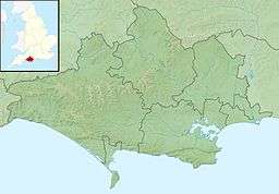 Location within Dorset | |
The River Piddle or Trent or North River is a small rural Dorset river which rises next to Alton Pancras church. Alton Pancras was originally named Awultune, a Saxon name meaning the village at the source of a river. The river's name has Germanic origins and has had various spellings over the years.[1] In AD 966 it was called the 'Pidelen', and on the church tower at Piddletrenthide—the first village to which it gives its name—it is spelled 'Pydel'.[1] Several villages which the river passes through are named after it: as well as Piddletrenthide there are Piddlehinton, Puddletown, Tolpuddle, Affpuddle, Briantspuddle and Turnerspuddle. Local legend tells that the Victorians changed the spelling to 'Puddle', due to 'piddle' being an alternative word for 'piss',[1] (although Puddletown was still called Piddletown into the 1950s), but see for instance the John Speed map of the county from 1610[2] which has the name 'Puddletown'.
The Piddle flows south and then south-easterly more or less parallel with its bigger neighbour, the River Frome, to Wareham, where they both enter Poole Harbour via Wareham Channel.
See also
Notes
Dorset Portal | |
| Unitary authorities | |
| Boroughs or districts | |
| Major settlements | |
| Rivers | |
| Topics | |