Rineyville, Kentucky
| Rineyville, Kentucky | |
|---|---|
| Census-designated place | |
 Rineyville  Rineyville | |
| Coordinates: 37°44′58″N 85°58′12″W / 37.74944°N 85.97000°WCoordinates: 37°44′58″N 85°58′12″W / 37.74944°N 85.97000°W | |
| Country | United States |
| State | Kentucky |
| County | Hardin |
| Elevation | 705 ft (215 m) |
| Time zone | UTC-5 (Eastern Time Zone) |
| • Summer (DST) | UTC-4 (EST) |
| ZIP code | 40162 |
| Area code(s) | 270 & 364 |
| FIPS code | 21-65388 |
| GNIS feature ID | 501960[1] |
Rineyville is an unincorporated community and census-designated place (CDP) in Hardin County, Kentucky, United States. It is located 7 miles (11 km) northwest of Elizabethtown, the county seat. The Paducah and Louisville Railway runs through the middle of town.
There is no formal town government; elected county officials oversee roads. The primary law enforcement agency for Rineyville is the Kentucky State Police – Post 4 in Elizabethtown. The Rineyville Fire Department, created in 1979, consists of 30-plus volunteers in the community. Some neighboring communities include Vine Grove to the north, Radcliff to the northeast, and Cecilia to the south.
Rineyville is named for past resident Zachariah Riney, the first school teacher of young Abraham Lincoln.[2]
References
- ↑ U.S. Geological Survey Geographic Names Information System: Rineyville, Kentucky
- ↑ Rennick, Robert M. Kentucky Place Names. University Press of Kentucky. p. 251. ISBN 0-8131-2631-2.
External links
Municipalities and communities of Hardin County, Kentucky, United States | ||
|---|---|---|
| Cities | 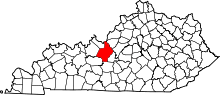 | |
| CDPs | ||
| Other unincorporated communities | ||
| Footnotes | ‡This populated place also has portions in an adjacent county or counties | |