Rice Fork Summer Homes, California
| Rice Fork Summer Homes | |
|---|---|
| Unincorporated community | |
 Rice Fork Eel River at Crabtree Hot Springs | |
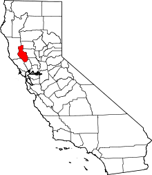
 Rice Fork Summer Homes Location in California  Rice Fork Summer Homes Rice Fork Summer Homes (the US) | |
| Coordinates: 39°23′59″N 122°57′02″W / 39.39972°N 122.95056°WCoordinates: 39°23′59″N 122°57′02″W / 39.39972°N 122.95056°W | |
| Country | United States |
| State | California |
| County | Lake County |
| Elevation[1] | 1,906 ft (581 m) |
Rice Fork Summer Homes is an unincorporated community in Lake County, California.[1] It lies at an elevation of 1906 feet (581 m).[1] As the name suggests, many of the residences function as second homes for their owners.
Rice Fork Summer Homes is located about 25 miles north of Upper Lake, at the bottom of Pine Mountain's northeast ridge, around a mile southeasterly of Scott Dam, on the west shore of the narrow winding steep walled canyon Rice Fork Eel River arm of Lake Pillsbury.
Elk Mountain Road connects the isolated community to the nearest town of Upper Lake.
References
- USGS LAKE PILLSBURY Quad, California, Topographic map - 1996
- USGS POTATO HILL Quad, California, Topographic map - 1996
- DFG Department of Fish and Game. 1993a. Rice Fork Eel River Stream Survey, August 16–19, Report by Kyle Murphy, Twyla Anderson, and Carl D. Reese
This article is issued from
Wikipedia.
The text is licensed under Creative Commons - Attribution - Sharealike.
Additional terms may apply for the media files.