Ribble and Alt Estuaries
| Site of Special Scientific Interest | |
 | |
 Location within Merseyside | |
| Area of Search | Merseyside |
|---|---|
| Grid reference | SD375240 |
| Coordinates | 53°43′N 2°58′W / 53.71°N 2.97°WCoordinates: 53°43′N 2°58′W / 53.71°N 2.97°W |
| Interest | Biological |
| Area | 9226.3 hectares, 22,798.2 acres (92,261,000 m2) |
| Notification |
1966 (Southport Sanctuary) |
| Designated | 28 November 1985 |
| Reference no. | 325[1] |
| Natural England website | |
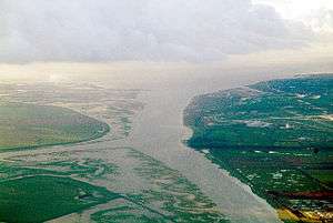
The Ribble Estuary in 1917.
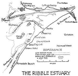
The Ribble and Alt Estuaries lie on the Irish Sea coast of the counties of Lancashire and Merseyside in north-west England, and form the boundaries of a number of nature preservation schemes.
Protected area
A large number of different species of waders and wildfowl, listed below, use the estuaries as feeding and over-wintering areas. This wide variety of bird species has led to the estuaries being officially designated as a Special Protection Area and as a Ramsar site. The Ribble Estuary has been designated a Site of Special Scientific Interest since 1966 and is now covered by Natural England's Ribble Estuary National Nature Reserve.
Species
Breeding season
- Common tern (Sterna hirundo)
- Lesser black-backed gull (Larus fuscus)
- Ruff (Philomachus pugnax)
Over wintering
- Bar-tailed godwit (Limosa lapponica)
- Black-tailed godwit (Limosa limosa islandica)
- Bewick's swan (Cygnus columbianus bewickii)
- Dunlin (Calidris alpina alpina)
- Golden plover (Pluvialis apricaria)
- Grey plover (Pluvialis squatarola)
- knot (Calidris canutus)
- Oystercatcher (Haematopus ostralegus)
- Pink-footed goose (Anser brachyrhynchus)
- Pintail (Anas acuta)
- Redshank (Tringa totanus)
- Sanderling (Calidris alba)
- Shelduck (Tadorna tadorna)
- Teal (Anas crecca)
- Whooper swan (Cygnus cygnus)
- Wigeon (Anas penelope)
Migratory
- Ringed plover (Charadrius hiaticula)
- Sanderling (Calidris alba)
See also
References
- ↑ "Ribble & Alt Estuaries". Ramsar Sites Information Service. Retrieved 25 April 2018.
- "Classification as a Special Protection Area". Joint Nature Conservation Committee.
- "SSSI citation sheet" (PDF). English Nature.
External links
This article is issued from
Wikipedia.
The text is licensed under Creative Commons - Attribution - Sharealike.
Additional terms may apply for the media files.