Rhaeticus (crater)
 Lunar Orbiter 4 image | |
| Coordinates | 0°00′N 4°54′E / 0.0°N 4.9°ECoordinates: 0°00′N 4°54′E / 0.0°N 4.9°E |
|---|---|
| Diameter | 43 × 49 km |
| Depth | 1.6 km |
| Colongitude | 254° at sunrise |
| Eponym | Georg J. Rheticus |

Rhaeticus is a lunar impact crater that lies astride the equator of the Moon, on the southeast edge of the Sinus Medii. More than 100 km north-northwest is the crater Triesnecker, around 75 to 80 km northeast is Dembowski, and due south can be found the worn remnant of the walled plain Hipparchus. About 150 km west from the middle of the crater on the equator is the origin (also the center) of the selenographic coordinate system at 0° N, 0° W. The crater was named for Georg Joachim von Lauchen, also known as Rheticus.[1]
Its diameter is 43 x 49 km long and is 1,600 meters deep. Also, the area is around 1,050 km² and the perimeter is around 125 km.
From that location the Earth would appear in the lunar sky at over 4 degrees from the top, sometimes due to librations, it appears about 7 degrees in different directions especially at the range of the zenith.
Description
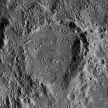
The outer wall of Rhaeticus is heavily disintegrated, with rifts and notches in the northeast. The wall is most intact along the eastern face, while in the northwest it is little more than a low rise in the surface. There is also a low cut in the south-southeast wall. The overall shape of the rim is that of a rough hexagon that is slightly elongated in the north-south direction. The interior has been resurfaced by lava, and only a few low rises remain in the surface. Beginning at the crest of the eastern wall is a chain of craterlets that continue to the east-northeast for about a crater diameter.[2]
Running southwest from Rhaeticus to the crater Réaumur is a long rille, which is difficult to make out near Rhaeticus because of the group of mountains at that crater's southwest. The crater itself is 43 kilometers wide at one diameter and 49 kilometers long at another. It is from the Pre-Imbrian period, which lasted from 4.55 to 3.85 billion years ago.[1]
Satellite craters
By convention these features are identified on lunar maps by placing the letter on the side of the crater midpoint that is closest to Rhaeticus.[3]
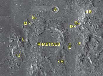
| Rhaeticus | Latitude | Longitude | Diameter |
|---|---|---|---|
| A | 1.8° N | 5.2° E | 11 km |
| B | 1.7° N | 6.8° E | 6 km |
| D | 0.9° N | 6.2° E | 7 km |
| E | 0.1° S | 6.0° E | 5 km |
| F | 0.1° S | 6.5° E | 18 km |
| G | 1.0° N | 6.4° E | 6 km |
| H | 1.0° S | 5.4° E | 6 km |
| J | 0.7° S | 3.2° E | 4 km |
| L | 0.2° N | 3.6° E | 14 km |
| M | 1.0° N | 3.8° E | 7 km |
| N | 1.2° N | 4.2° E | 12 km |
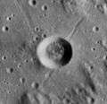 Lunar Orbiter 4 image of Rhaeticus A
References
- 1 2 Autostar Suite Astronomer Edition. CD-ROM. Meade, April 2006.
- ↑ Wlasuk, Peter T. (2000). Observing the Moon. Springer. ISBN 1-85233-193-3.
- ↑ Bussey, B.; Spudis, P. (2004). The Clementine Atlas of the Moon. New York: Cambridge University Press. ISBN 0-521-81528-2.
External links
| Wikimedia Commons has media related to Rhaeticus (crater). |
- Rhaeticus at the Moon Wiki
Related articles
- Wood, Chuck (February 2, 2006). "Layers of History". Lunar Photo of the Day. Archived from the original on August 22, 2017.