Reva, Belgrade
Reva (Serbian: Рева) is an urban neighborhood of Belgrade, the capital of Serbia. It is a sub-neighborhood of Krnjača and is located in Belgrade's municipality of Palilula. According to the 2011 census, it had a population of 2,522.
Location
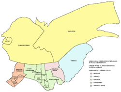
Reva is located in the Banat section of the municipality of Palilula. It is situated between the Krnjača's sub-neighborhoods Blok Zaga Malivuk and Janko Lisjak on the west and Blok Braća Marić on the southwest, Ovča on the north, Pančevo on the east and the Danube on the south.[1][2]
It mostly stretches along the road of Pančevački put, which connects Belgrade to the town of Pančevo in the east.[2][3]
It occupies the entire eastern section of Krnjača, larger in territory than the western sections (Dunavski Venac and Kotež), but much less populated.
Geography
It is situated in the southeast section of the Pančevački Rit floodplain, between the Danube and Tamiš rivers. Remnants of the floodplain include the bogs of Veliko Blato, just west of the neighborhood and Reva, so as numerous minor, mostly channeled flows which drain the land and empty into the Danube: Sebeš, Kalovita, Dunavac, Sibnica, Velika Vrtača, Mala Vrtača, Spoljni Kanal, etc.[2][3]
The entire left bank of the Danube is an embankment, built to protect the land from flooding. Former adas, river islands, have been turned into the embankments and are now part of the land, like Ovčanska Ada, Čapljin, etc. The mostly un-urbanized eastern part consists of fields Ovča Greda, Široki Rit, Vrtače, Crkvište, Veliko Blato. Unrelated to the bog of the same name on the west, Veliko Blato is partially urbanized, as the settlement of Sibnica is located here.[3]
Bog
Reva Bog (Serbian: Бара Рева) is located close to the Danube's left bank, in marshy and floodprone terrain. Part of it has been turned into a fish pond. It is elongated in the west-to-east direction, parallel to the flow of the Sebeš stream.[2][3] With other marshy areas in Krnjača it is the major breeding ground for the mosquitoes which causes annoyance for the population of Belgrade during summer.
Neighborhood
Reva is one of the sub-neighborhoods of Krnjača. The settlement is scattered and consists of several discontinued built-up areas. Blok Zaga Malivuk, Reva and Reva 2 are located in the western section, along the Pančevački put, and are proper extension of Krnjača. Ovčanski Sebeš is separated to the north, across the Sebeš stream, on the railway in Ovča direction. Čapljin is a weekend-settlement on the Danube, on the former island of the same name. It is located right across another weekend-settlement, Bela Stena, on western tip of the Forkontumac island, which is administratively part of Pančevo. Sub-neighborhood of Sibnica is located in the easternmost section, close to the Tamiš river and town of Pančevo itself.[3]
Administration
| Historical population | ||
|---|---|---|
| Year | Pop. | ±% |
| 1981 | 1,578 | — |
| 1991 | 1,963 | +24.4% |
| 2002 | 2,808 | +43.0% |
| 2011 | 2,522 | −10.2% |
| Source: [4][5][6][7] | ||
Reva is organized as a local community, sub-municipal administrative unit, within the municipality of Palilula. The local community was called Reva until the 2002 census, while for the 2011 census it was renamed Bara Reva.[4][5][6][7]
Economy
Reva is primarily industrial and economic zone. Industry includes numerous facilities of the formerly large, state owned companies many of which went bankrupt during the transition period and are now turned into the large hangars and storage facilities. Companies include: Trudbenik Gradnja, IMK Beograd, Jugonemija, Oil Refinery Belgrade, Ovča gass filling facility, Veterinarian Institute, etc. It is also known for its nursery gardens (Rasadnik Reva, and other).[3]
The road of Pančevački put, which starts at the Pančevo Bridge, passed right through the neighborhood. The Belgrade-Pančevo Railway marks the northern border of the neighborhood and separates it from Ovča. There are railway stations in Ovčanski Sebeš and Ovča.[2][3]
In 2018 it was announced that Reva is to be included in the future Belgrade port area, since the present Port of Belgrade, located across the Danube in the neighborhood of Viline Vode, is scheduled for relocation. For now, Reva is envisioned as the temporary location for the numerous gravel loading facilities from the banks in downtown Belgrade on both the Danube and Sava rivers, which should be relocated, too. The starting date for the beginning of the removal is set for April 2018, the detailed regulatory plan for the new port area should be finished sometime in 2018, while the technical documentation for the future bulk cargo terminal should be prepared in 2019.[8]
References
- ↑ Tamara Marinković-Radošević (2007). Beograd - plan i vodič. Belgrade: Geokarta. ISBN 86-459-0006-8.
- 1 2 3 4 5 Beograd - plan grada. Smedrevska Palanka: M@gic M@p. 2006. ISBN 86-83501-53-1.
- 1 2 3 4 5 6 7 Slobodan Radovanović (2007). Belgrade and surrounding places. Smederevska Palanka: Magic Map. ISBN 978-86-7802-004-9.
- 1 2 Osnovni skupovi stanovništva u zemlji – SFRJ, SR i SAP, opštine i mesne zajednice 31.03.1981, tabela 191. Savezni zavod za statistiku (txt file). 1983.
- 1 2 Stanovništvo prema migracionim obeležjima – SFRJ, SR i SAP, opštine i mesne zajednice 31.03.1991, tabela 018. Savezni zavod za statistiku (txt file).
- 1 2 Popis stanovništva po mesnim zajednicama, Saopštenje 40/2002, page 4. Zavod za informatiku i statistiku grada Beograda. 26 July 2002.
- 1 2 Stanovništvo po opštinama i mesnim zajednicama, Popis 2011. Grad Beograd – Sektor statistike (xls file). 23 April 2015.
- ↑ Daliborka Mučibabić (22 February 2018). "Рашчишћавање нелегалних шљункара" [Removal od the illegal gravel facilities]. Politika (in Serbian).