Reintalanger Hut
| Reintalanger Hut | |
|---|---|
 | |
 Reintalanger Hut | |
| Coordinates | 47°24′19″N 11°02′08″E / 47.40528°N 11.03556°ECoordinates: 47°24′19″N 11°02′08″E / 47.40528°N 11.03556°E |
| Country | Germany |
| Location | at the head of the Reintal |
| Elevation | 1,366 m (4,482 ft) above sea level |
| Administration | |
| Hut type | DAV Hut Category I |
| Owner | DAV section of Munich |
| Website |
www |
| Facilities | |
| Beds/Bunks | 27[1] |
| Mattresses | 87[1] |
| Winter room | 18[1] |
| Accommodation | AV-Schloss |
| Opening times | end May to 3rd weekend in October |
| Footnotes | |
| Hut reference | OeAV DAV |
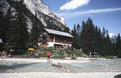
The Reintalanger Hut (1,366 m) is an Alpine Club hut in the Wetterstein Mountains at the head of the Reintal valley. The River Partnach has its source in the vicinity. West of the hut the valley floor climbs steeply up to the plateau of the Zugspitzplatt below Germany's highest mountain.
The hut belongs to the Munich section of the German Alpine Club and the administrative district of Garmisch-Partenkirchen. It was built in 1912[1] and is a Category 1 hut.[1] The house has 132 bedspaces and is managed from the end of May to mid-October.[1]
History
The use of the pasture of the Reintalangeralm is discernible as early as 1485. It was often used by Tyrolese subjects from the Leutasch, who drove their cattle there via the Ehrwalder Gatterl.[2]
Description
The hut sits above the wide, rock-strewn riverbed of the Partnach at a height of around 1,370 metres in a "glorious location with magnificent views"[3] of the Gatterlköpfe, Plattspitzen and Kleinwanner.[3] By tradition, overnight visitors are roused by a musical wake-up call.[3]
Approaches
- from the glacier station of Sonn Alpin on the Bavarian Zugspitze Railway via the Knorr Hut (ca. 2 hours descent).
- from the Partenkirchen Ski Stadium through the Partnach Gorge and the Reintal valley (ca. 5 hours)
- from the Kreuzeckhaus along the lower Bernadeinweg path, the Bock Hut and through the Reintal (4½ hours, sure-footedness required)
Crossings
- Knorr Hut (2 hrs.)
- via the Bock Hut and lower Bernardeinweg to the Kreuzeckhaus (5–6 hours)
- via the Mauerscharte col, Stuiben Hut and Lower Bernadeinweg to the Kreuzeckhaus (so-called Schützensteig; 5½ hours; alpine experience, sure-footedness, head for heights and navigation skills required)
- via the Bock Hut to the Oberreintal Hut (3 hrs.)
- via the Bock Hut, Oberreintal and Schachenhaus (4 hrs.) to the Meiler Hut (6 hours; sure-footedness required)
Climbing routes
- For climbers the highest Wetterstein face, the 1,400 metre high Hochwanner north face, has several options.
Gallery
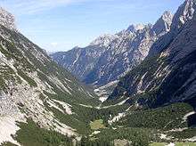 The Reintal valley and Reintalanger Hut from the west
References
- 1 2 3 4 5 6 Reintalangerhütte 1369 m at www.alpenverein-muenchen-oberland.de. Retrieved 30 Mar 2018.
- ↑ Johannes Haslauer: "Nur für sehr geübte Steiger" Voralpinistische Annäherungen an das Wettersteingebirge und die Zugspitze. In: Alpenvereinsjahrbuch Berg 2010. Vol. 134, 2010, p. 166.
- 1 2 3 Bourne Grant and Sabine Körner-Bourne. Walking in the Bavarian Alps, 3rd edn. Milnthorpe: Cumbria, 2012, p. 139.