Partnach
| Partnach | |
|---|---|
 The Partnach in the Reintal valley | |
| Location | Garmisch-Partenkirchen district |
| Reference no. | DE: 1624 |
| Physical characteristics | |
| Main source |
on the Zugspitze Massif ca. 1,440 m 47°N 11°E / 47°N 11°E |
| River mouth |
in Garmisch-Partenkirchen into the Loisach ca. 690 m 47°N 11°E / 47°N 11°ECoordinates: 47°N 11°E / 47°N 11°E |
| Length | 18.0 km (11.2 mi) [1] |
| Basin features | |
| Progression | Loisach→ Isar→ Danube→ Black Sea |
The Partnach is an 18 km long Bavarian mountain river. It rises at a height of 1,440 m on the Zugspitze Massif. The Partnach is fed by meltwaters from the Schneeferner glacier some 1100 m higher up. The glacier’s meltwaters seep into the karsty bedrock and reach the surface again near the source of the Partnach.
The Partnach then flows down the Reintal valley. Until 2005 there were two mountain lakes here – the Vordere and Hintere Blaue Gumpe. At the first lake the water of the Partnach was impounded by scree from rock slides. As a result of heavy rain the natural dam, caused by rockfalls, was partially carried away and the lake was completed filled with sediment. As a result the Blaue Gumpe does not exist any longer today.
Tributaries
The Partnach has the following tributaries which join it at or near the river kilometre shown in brackets:
- Kanker (0.9)
- Boddenberggraben (3.2)
- Hornschlittengraben (4.1)
- Eselsberggraben (4.4)
- Wildsaugraben (4.7)
- Graseckgraben (4.8)
- Streichlagraben (4.9)
- Ferchenbach (6.0 )
- Sulzgraben (7.8 )
- Klausengraben (8.2)
- Bodenlaine (8.3)
- Spitzwaldgraben (8.5)
- Ferlsbach (9.3 )
- Reintalbach (11.1)
Gallery
 The Partnach at the Reintalanger Hut
 Source of the Partnach
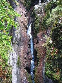 The Partnachklamm from above
 Entrance to the Partnachklamm
Sources
References
- ↑ Complete table of the Bavarian Waterbody Register by the Bavarian State Office for the Environment (xls, 10.3 MB)