Reid Street–North Confederate Avenue Area Historic District
|
Reid Street–North Confederate Avenue Area Historic District | |
 | |
  | |
| Location | Roughly, Reid St. and N. Confederate Ave. between E. Main St. and E. White St., Rock Hill, South Carolina |
|---|---|
| Coordinates | 34°55′26″N 81°1′19″W / 34.92389°N 81.02194°WCoordinates: 34°55′26″N 81°1′19″W / 34.92389°N 81.02194°W |
| Area | 10 acres (4.0 ha) |
| Architect | Multiple |
| Architectural style | Classical Revival, Bungalow/craftsman, Late Victorian |
| MPS | Rock Hill MPS |
| NRHP reference # | 92000657[1] |
| Added to NRHP | June 10, 1992 |
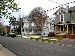
Reid Street–North Confederate Avenue Area Historic District is a national historic district located at Rock Hill, South Carolina. It encompasses 22 contributing buildings in a middle-class residential section of Rock Hill. The district developed between about 1839 and 1935. Architectural styles represented include Victorian, Classical Revival, Queen Anne, and Bungalow. Notable buildings include the Steed House (c. 1905), Bynum House (c. 1902), Jenkins House (c. 1905), and Gross-Brock House (c. 1905), along with the separately listed White House.[2][3]
It was listed on the National Register of Historic Places in 1992.[1]
References
- 1 2 National Park Service (2010-07-09). "National Register Information System". National Register of Historic Places. National Park Service.
- ↑ Paul M. Gettys (September 1990). "Reid Street–North Confederate Avenue Area Historic District" (pdf). National Register of Historic Places - Nomination and Inventory. Retrieved 2014-07-01.
- ↑ "Reid Street–North Confederate Avenue Area Historic District, York County (Rock Hill)". National Register Properties in South Carolina. South Carolina Department of Archives and History. Retrieved 2014-07-01. and accompanying map
| Topics |   | |
|---|---|---|
| Lists by county |
| |
| Lists by city | ||
| Other lists | ||
This article is issued from
Wikipedia.
The text is licensed under Creative Commons - Attribution - Sharealike.
Additional terms may apply for the media files.