Rehobeth, Maryland
| Rehobeth, Maryland | |
|---|---|
| Unincorporated community | |
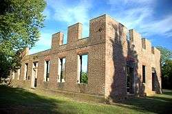 Coventry Parish ruins | |
 Rehobeth | |
| Coordinates: 38°02′20″N 75°39′47″W / 38.03889°N 75.66306°WCoordinates: 38°02′20″N 75°39′47″W / 38.03889°N 75.66306°W | |
| Country |
|
| State |
|
| County |
|
| Elevation | 3 m (10 ft) |
| Time zone | UTC-5 (Eastern (EST)) |
| • Summer (DST) | UTC-4 (EDT) |
| ZIP code | 21857 |
| Area code(s) | 410, 443, and 667 |
| GNIS feature ID | 591110[1] |
Rehobeth is an unincorporated community in Somerset County, Maryland, United States.[1] It is located at the east end of Old Rehobeth Road, off Rehobeth Road, on the bank of the Pocomoke River. Caldicott, Coventry Parish Ruins, and Rehobeth Presbyterian Church are listed on the National Register of Historic Places.[2]
The community was named after Rehoboth, a place mentioned in the Hebrew Bible, via a local plantation of that name.[3]
References
- 1 2 "Rehobeth". Geographic Names Information System. United States Geological Survey.
- ↑ National Park Service (2010-07-09). "National Register Information System". National Register of Historic Places. National Park Service.
- ↑ Federal Writers' Project (1938). The Ocean Highway: New Brunswick, New Jersey to Jacksonville, Florida. Works Progress Administration. p. 56.
Municipalities and communities of Somerset County, Maryland, United States | ||
|---|---|---|
| City |  | |
| Town | ||
| CDPs | ||
| Other communities | ||
This article is issued from
Wikipedia.
The text is licensed under Creative Commons - Attribution - Sharealike.
Additional terms may apply for the media files.