Cokesbury, Maryland
| Cokesbury, Maryland | |
|---|---|
| Unincorporated community | |
 Cokesbury | |
| Coordinates: 38°07′37″N 75°34′45″W / 38.12694°N 75.57917°WCoordinates: 38°07′37″N 75°34′45″W / 38.12694°N 75.57917°W | |
| Country |
|
| State |
|
| County |
|
| Elevation | 6 m (20 ft) |
| Time zone | UTC-5 (Eastern (EST)) |
| • Summer (DST) | UTC-4 (EDT) |
| ZIP code | 21851 |
| Area code(s) | 410, 443, and 667 |
| GNIS feature ID | 583833[1] |
Cokesbury is an unincorporated community in Somerset County, Maryland, United States.[1] It is east of U.S. Route 13 near the Pocomoke River, at the intersection of Wallace Taylor Road, Cokesbury Road, and Courthouse Hill Road. Burton Cannon House was listed on the National Register of Historic Places in 1975.[2]
References
- 1 2 "Cokesbury". Geographic Names Information System. United States Geological Survey.
- ↑ National Park Service (2010-07-09). "National Register Information System". National Register of Historic Places. National Park Service.
Municipalities and communities of Somerset County, Maryland, United States | ||
|---|---|---|
| City | 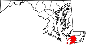 | |
| Town | ||
| CDPs | ||
| Other communities | ||
This article is issued from
Wikipedia.
The text is licensed under Creative Commons - Attribution - Sharealike.
Additional terms may apply for the media files.