Regen
| Regen | ||
|---|---|---|
 Regen | ||
| ||
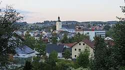
 Regen Location of Regen within Regen district 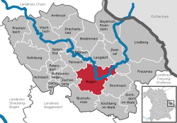 | ||
| Coordinates: 48°58′N 13°8′E / 48.967°N 13.133°ECoordinates: 48°58′N 13°8′E / 48.967°N 13.133°E | ||
| Country | Germany | |
| State | Bavaria | |
| Admin. region | Lower Bavaria | |
| District | Regen | |
| Government | ||
| • Mayor | Ilse Oswald (FW) | |
| Area | ||
| • Total | 65.15 km2 (25.15 sq mi) | |
| Elevation | 530 m (1,740 ft) | |
| Population (2017-12-31)[1] | ||
| • Total | 10,967 | |
| • Density | 170/km2 (440/sq mi) | |
| Time zone | CET/CEST (UTC+1/+2) | |
| Postal codes | 94209 | |
| Dialling codes | 09921 | |
| Vehicle registration | REG | |
| Website | www.regen.de | |

Regen is a town in Bavaria, Germany, and the district town of the district of Regen.
Geography
Regen is situated on the great Regen River, located in the Bavarian Forest.
Divisions
Originally the town consisted of 4 districts: Bürgerholz, Grubhügel, Riedham and St. Johann.
After a governmental reform the villages of Aden, Augrub, Bärndorf, Bettmannsäge, Dreieck, Ebenhof, Ecklend, Edhof, Eggenried, Finkenried, Frauenmühle, Großseiboldsried, Huberhof, Kagerhof, Kattersdorf, Kerschlhöh, Kleinseiboldsried, Kreuzerhof, Kühhof, March, Maschenberg, Matzelsried, Metten, Neigerhöhe, Neigermühle, Neusohl, Obermitterdorf, Oberneumais, Oleumhütte, Pfistermühle, Pometsau, Poschetsried, Reinhartsmais, Richtplatz, Rinchnachmündt, Rohrbach, Sallitz, Schauerhof, Schlossau, Schochert, Schollenried, Schönhöh, Schützenhof, Schwaighof, Schweinhütt, Spitalhof, Sumpering, Tausendbach, Thanhof, Thurnhof, Weißenstein, Weißensteiner-Au, Wickersdorf, Wieshof and Windschnur were added.
Population development
- 1280: 200
- 1828: 1196
- 1904: 2366
- 1974: 9029
- 2005: 12.553
- 2015: 10.855
International relations
Regen is twinned with:
Notable places
The "Niederbayrisches Landwirtschaftsmuseum" is a museum showing the history of agriculture and society in Lower Bavaria from the 18th and 19th century.
The "Fressendes Haus" is a former domicile of the poets Clara Nordström (1886–1962) and Siegfried von Vegesack (1888–1974), which was transformed in a museum in 1984 presenting different expositions of historical art and the archeological excavations at the castle ruin of Weißenstein.
Natural monuments
- The Pfahl is a 150-kilometre-long quartz ridge. In the vicinity of Weißenstein it reaches its highest point at 750 metres at the site of Weißenstein Castle.
Economy
Tourism figures largely in the local economy, with over 64,000 visitors accounting for 220,000 over-night stays last year.
Personalities
- Clara Nordström, Swedish writer (1886-1962)
References
- ↑ "Fortschreibung des Bevölkerungsstandes". Bayerisches Landesamt für Statistik und Datenverarbeitung (in German). September 2018.
External links
| Look up regen in Wiktionary, the free dictionary. |
- Official website

- Pichelsteinerfest Regen (in German)
Towns and municipalities in Regen (district) | ||
|---|---|---|