Reed Township, Seneca County, Ohio
| Reed Township, Seneca County, Ohio | |
|---|---|
| Township | |
 | |
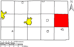 Location of Reed Township in Seneca County | |
| Coordinates: 41°7′55″N 82°53′24″W / 41.13194°N 82.89000°WCoordinates: 41°7′55″N 82°53′24″W / 41.13194°N 82.89000°W | |
| Country | United States |
| State | Ohio |
| County | Seneca |
| Area | |
| • Total | 38.5 sq mi (99.7 km2) |
| • Land | 38.5 sq mi (99.7 km2) |
| • Water | 0.0 sq mi (0.0 km2) |
| Elevation[1] | 899 ft (274 m) |
| Population (2010) | |
| • Total | 848 |
| • Density | 22.0/sq mi (8.5/km2) |
| Time zone | UTC-5 (Eastern (EST)) |
| • Summer (DST) | UTC-4 (EDT) |
| ZIP code | 44807 |
| Area code(s) | 419 |
| FIPS code | 39-65942[2] |
| GNIS feature ID | 1086952[1] |
Reed Township is one of the fifteen townships of Seneca County, Ohio, United States. The 2010 census found 848 people in the township.[3]
Geography
Located in the eastern part of the county, it borders the following townships:
- Thompson Township – north
- Sherman Township, Huron County – northeast
- Norwich Township, Huron County – southeast
- Venice Township – south
- Bloom Township – southwest corner
- Scipio Township – west
- Adams Township – northwest corner
No municipalities are located in Reed Township, but it does contain the unincorporated community of West Lodi.
Name and history
Reed Township was organized in 1826, and named in honor of Seth Reed[4] (or Seth Read),[5] a pioneer settler. It is the only Reed Township statewide.[6]
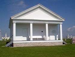
Omar Chapel is a historical property in Reed Township which once was a stop on the Underground Railroad. It was completed in 1843 and is listed on the National Register of Historic Places.
Government
The township is governed by a three-member board of trustees, who are elected in November of odd-numbered years to a four-year term beginning on the following January 1. Two are elected in the year after the presidential election and one is elected in the year before it. There is also an elected township fiscal officer,[7] who serves a four-year term beginning on April 1 of the year after the election, which is held in November of the year before the presidential election. Vacancies in the fiscal officership or on the board of trustees are filled by the remaining trustees.
References
- 1 2 "US Board on Geographic Names". United States Geological Survey. 2007-10-25. Retrieved 2008-01-31.
- ↑ "American FactFinder". United States Census Bureau. Retrieved 2008-01-31.
- ↑ "American FactFinder". United States Census Bureau. Retrieved 26 July 2018.
- ↑ Baughman, Abraham J. (1911). History of Seneca County, Ohio: A Narrative Account of Its Historical Progress, Its People, and Its Principal Interests. Lewis Publishing Company. p. 473.
- ↑ Lang, William (1880). History of Seneca County, from the Close of the Revolutionary War to July, 1880. Springfield, Ohio: Transcript Printing Company. p. 578.
- ↑ "Detailed map of Ohio" (PDF). United States Census Bureau. 2000. Retrieved 2007-02-16.
- ↑ §503.24, §505.01, and §507.01 of the Ohio Revised Code. Accessed 4/30/2009.
External links
Municipalities and communities of Seneca County, Ohio, United States | ||
|---|---|---|
| Cities | 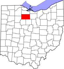 | |
| Villages | ||
| Townships | ||
| CDPs | ||
| Unincorporated communities | ||
| Ghost towns | ||
| Footnotes | ‡This populated place also has portions in an adjacent county or counties | |