Red Wing, Colorado
| Red Wing, Colorado Point of Rocks | |
|---|---|
| Unincorporated community | |
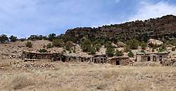 Some old dwellings in Red Wing | |
 Red Wing Location of Red Wing in Huerfano County, Colorado  Red Wing Red Wing (the US) | |
| Coordinates: 37°44′10″N 105°17′24″W / 37.73611°N 105.29000°WCoordinates: 37°44′10″N 105°17′24″W / 37.73611°N 105.29000°W[1] | |
| Country |
|
| State |
|
| Counties | Huerfano |
| Elevation[1] | 7,726 ft (2,355 m) |
| Time zone | UTC-7 (MST) |
| • Summer (DST) | UTC-6 (MDT) |
Red Wing is an unincorporated community in Huerfano County, Colorado, United States.
Geography
Red Wing is located at 37°44′10″N 105°17′24″W / 37.73611°N 105.29000°W (37.7361158,-105. 2900038). The community lies southwest of Gardner and just east of the Sangre de Cristo Range along County Road 580 in the Huerfano River Valley. The community is agrarian and has many interesting geological features, such as faults, outcrops of Dakota sandstone, and igneous intrusions.[2]
References
- 1 2 "Red Wing". Geographic Names Information System. United States Geological Survey.
- ↑ "Red Wing, Colorado". Sangres.com. Retrieved 2018-05-03.
Municipalities and communities of Huerfano County, Colorado, United States | ||
|---|---|---|
| City | 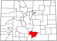 | |
| Town | ||
| Unincorporated communities | ||
| Ghost towns | ||
This article is issued from
Wikipedia.
The text is licensed under Creative Commons - Attribution - Sharealike.
Additional terms may apply for the media files.