Red Line (St. Louis MetroLink)
| Red Line | |
|---|---|
 Red Line train at Union Station | |
| Overview | |
| Type | Light rail |
| System | St. Louis MetroLink |
| Locale | Greater St. Louis |
| Termini |
Lambert Airport Main (west) Shiloh-Scott (east) |
| Stations | 28 |
| Operation | |
| Opened | July 31, 1993 |
| Operator(s) | Metro |
| Technical | |
| Line length | 38-mile (61 km) |
| Track gauge | 1,435 mm (4 ft 8 1⁄2 in) |
| Electrification | Overhead lines, 750 V DC |
| Highest elevation | at-grade, elevated, and underground |
The Red Line of the St. Louis MetroLink is a light rail service operating between 28 stations in Greater St. Louis. It is the oldest and longest line in the system.
Route description
The 38-mile (61 km) Red Line MetroLink alignment begins at Lambert St. Louis International Airport, making stops at the main and east terminal stations. It then proceeds through Kinloch before making a stop in North Hanley near Bel-Ridge. It makes 2 stops (UMSL North & South stations) at the University of Missouri St. Louis located in Normandy. After departing UMSL-North Station, the trains divert south onto the former Wabash/Norfolk & Western Railroad's Union Depot (U.D.) line that once brought passenger trains from Ferguson to Union Station. It further follows into 2 stops in Pagedale on St. Charles Rock Road and Wellston on Plymouth St., before crossing the St. Louis City/County boundary line at Skinker Boulevard; and making a stop at Delmar Boulevard, serving the popular Delmar Loop and located just below the original Wabash Railroad's Delmar Station building. The Red Line meets up with the Blue Line at the Forest Park-DeBaliviere station. From this station to the Fairview Heights station in Illinois, it creates the Shared Alignment track with the Blue Line. It terminates in Shiloh next to the Scott Air Force Base and close to the Mid-America Airport in Mascoutah.
Future extensions
Some of these extensions will make the Red Line one of the longest light rail lines in the United States.
St. Clair County Extension
St. Clair County Extension Phase 3 - Shiloh-Scott to MidAmerica Airport: the St. Clair County Extension Phase III will extend 5.3-mile (8.5 km) to MidAmerica Airport. Although design work for the extension has been completed, funding for construction hasn't been secured. It was originally part of the St. Clair County Extension Phase II project that extended to Shiloh-Scott, but was separated into its own project by the Federal Transit Administration due to projections of low ridership. If this extension had been built, it would have been 43.3-mile (69.7 km) on this route alone.
Madison County Corridors
Madison County Corridors - East St. Louis to Alton/Edwardsville: A study in 2005 was performed to investigate the potential costs, ridership, and impacts of extending Metrolink into Madison County, Illinois. According to the East-West Gateway Council of Governments, there are two recommended alignments for Madison County. Both of the alignments will start from the 5th & Missouri station out of East St Louis in St. Clair County to Granite City, Collinsville, Glen Carbon, Edwardsville, East Alton, Wood River, and Alton in Madison County, Illinois 21–23-mile (34–37 km) away. The alignments will junction off in Madison, Illinois into two alignments. In order to plan out the two alignments, Metro will have to collaborate with Madison County Transit.
St. Charles Corridor
St. Charles Corridor - Lambert Airport to St. Charles County: Possible plans to expand MetroLink 16–20-mile (26–32 km) from Lambert Airport northwestward to St. Charles County were abandoned after St. Charles County voters rejected a sales tax in 1996 to fund an extension; subsequently, all MetroBus service was ended. If the extension was funded, the route would have used the Old St. Charles Bridge (now demolished) as a crossing over the Missouri River to the City of St. Charles, St. Peters, and O'Fallon. In the near future, it may be considered a potential alignment to study.
Station list
From Lambert Airport to Shiloh-Scott (west to east)
| Station | Blue Line (shared) |
City/town served | County | Opening year |
|---|---|---|---|---|
| Lambert Airport Terminal 1 | Edmundson | St. Louis County | 1994 | |
| Lambert Airport Terminal 2 | Woodson Terrace | 1998 | ||
| North Hanley | Carsonville | 1993 | ||
| UMSL North | Normandy | 1993 | ||
| UMSL South | 1993 | |||
| Rock Road | Pagedale | 1993 | ||
| Wellston | Pagedale | 1993 | ||
| Delmar Loop | St. Louis | St. Louis independent city | 1993 | |
| Forest Park–DeBaliviere | 1993 | |||
| Central West End | 1993 | |||
| Grand | 1993 | |||
| Union Station | 1993 | |||
| Civic Center | 1993 | |||
| Central West End | 1993 | |||
| Stadium | 1993 | |||
| 8th & Pine | 1993 | |||
| Convention Center | 1993 | |||
| Laclede's Landing | 1993 | |||
| East Riverfront | East St. Louis | St. Clair County | 1994 | |
| 5th & Missouri | 1993 | |||
| Emerson Park | 2001 | |||
| Jackie Joyner-Kersee Center | 2001 | |||
| Washington Park | 2001 | |||
| Fairview Heights | Fairview Heights | 2001 | ||
| Memorial Hospital | Belleville | 2001 | ||
| Swansea | Swansea | 2001 | ||
| Belleville | Belleville | 2001 | ||
| College | 2001 | |||
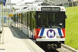
| Shiloh–Scott | Shiloh | 2003 |
See also
References
External links
Route map:
| Lines | ||
|---|---|---|
| Infrastructure | ||
| Rolling Stock | ||
| Rail yards | ||
| Connections | ||
| Connecting services | ||
| Proposed expansions | ||
| Operators | ||
Italic denote lines or services which are proposed and planned. | ||