Rayón, State of Mexico
| Rayón | |
|---|---|
| Municipality and town | |
 | |
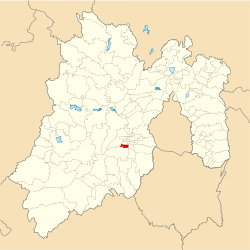 Location of the municipality in Mexico State | |
| Country |
|
| State | Mexico (state) |
| Government | |
| • Municipal president | José Luis Robles Vázquez |
| Elevation | 2,570 m (8,430 ft) |
| Population (2005) | |
| • Total | 12,748 |
| Time zone | UTC-6 (Central Standard Time) |
| • Summer (DST) | UTC-5 (Central Daylight Time) |
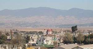
Rayón is the municipality located in Toluca Region, the northeastern part of the state of Mexico in Mexico, the municipal seat is Santa María Rayón, formerly named Cuauhtenco. The municipality is located at a southern pass leading out of the Toluca Valley.[1]
Geography
The total municipality extends 84.37 km2 and borders with the municipalities of Tenango del Valle, Calimaya and Almoloya del Río.
Communication and transport
The Lerma-Tenango Highway, is a main highway that cross by Rayón, connect with Toluca to Tenango del Valle.
Politics
| Mayor | Time |
|---|---|
| Elias Arturo Sánchez Montes de Oca | 2009–2012 |
| Erick Vladimir Cedillo Hinojosa | 2012–2015 |
| José Luis Robles Vázquez | 2016– |
Economy
The economy is principally farming, cattle raising and small businesses, concentrating on the production of corn, beans and fruit.
Demography
Populated places in Rayón
| Town | Population |
| Total | 12 748 |
| Santa María Rayón |
Culture
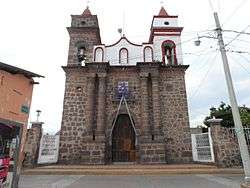
Guadalupe Church in Rayón.
Monuments
- Saint Mary of Guadalupe Parish is a monument in Rayón town.
References
- ↑ "Rayón". Enciclopedia de los Municipios de México. Instituto Nacional para el Federalismo y el Desarrollo Municipal. Archived from the original on August 19, 2016. Retrieved June 6, 2009.

This article is issued from
Wikipedia.
The text is licensed under Creative Commons - Attribution - Sharealike.
Additional terms may apply for the media files.