Rawatpura, Kulpahar
| Rawatpura | |
|---|---|
| village | |
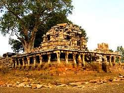 Chandela temple near Rawatpura lake | |
 Rawatpura Location in Uttar Pradesh, India  Rawatpura Rawatpura (India) | |
| Coordinates: 25°15′38″N 79°39′46″E / 25.260687°N 79.662724°ECoordinates: 25°15′38″N 79°39′46″E / 25.260687°N 79.662724°E | |
| Country |
|
| State | Uttar Pradesh |
| Government | |
| • Body | Gram panchayat |
| Languages | |
| • Official | Hindi |
| Time zone | UTC+5:30 (IST) |
| Vehicle registration | UP |
| Website |
up |
Rawatpura is a tiny village 10 km east of Kulpahar, in the state of Uttar Pradesh, India.[1] It has many ruins of temples of the Chandela dynasty.
References
This article is issued from
Wikipedia.
The text is licensed under Creative Commons - Attribution - Sharealike.
Additional terms may apply for the media files.