Ratyshchi
| Ratyshchi Ратищі | |
|---|---|
| Village | |
 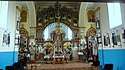 From Upper left: (1) Holy Dormition temple in the village Ratyshchi; (2) Inside interior Holy Dormition church in the village Ratyshchi. | |
 Ratyshchi | |
| Coordinates: 49°50′07″N 25°18′31″E / 49.83528°N 25.30861°ECoordinates: 49°50′07″N 25°18′31″E / 49.83528°N 25.30861°E | |
| Country |
|
| Province |
|
| District | Zboriv Raion |
| Area | |
| • Total | 0.87 km2 (0.34 sq mi) |
| Elevation | 318 m (1,043 ft) |
| Population | |
| • Total | 311 |
| • Density | 362.070/km2 (937.76/sq mi) |
| Time zone | UTC+2 (EET) |
| • Summer (DST) | UTC+3 (EEST) |
| Website | село Ратищі (in Ukrainian) |
Ratyshchi (Ukrainian: Ра́тищі; Polish: Ratyszcze) is a village (selo) in the Zboriv Raion, Ternopil Oblast (province in western Ukraine).
Local government – Ratyshchivska village council.[1] Unto her is subordinated to the village Pishchane. The village is situated on the banks of the Seret River which is the left tributary of the Dniester.
Village Ratyshchi distant from the administrative center of Ternopil 45 kilometres (28 mi), from Zboriv — 32 kilometres (20 mi), and from Lviv — 102 kilometres (63 mi).
The first written record dates from the 12th century.[2]
Notes
- ↑ Ратищівська сільська рада (in Ukrainian)
- ↑ (in Ukrainian)
References
- У ЗБОРОВІ ВШАНУВАЛИ РАТИЩІВСЬКУ ІКОНУ ПРЕСВЯТОЇ БОГОРОДИЦІ (in Ukrainian)
- weather.in.ua
- Pogoda w Ratyshchi (in Polish)
Literature
- Ukrainian: Історія міст і сіл УРСР : Тернопільська область. – К. : ГРУРЕ, 1973 р. – 640 с.
| Cities | ||
|---|---|---|
| Urban-type settlements | ||
| Villages |
| |
This article is issued from
Wikipedia.
The text is licensed under Creative Commons - Attribution - Sharealike.
Additional terms may apply for the media files.