Ramechhap, Ramechhap
| Ramechhap Nagarpalika रामेछाप | |
|---|---|
| Motto(s): Shailung | |
 Ramechhap Nagarpalika Location in Nepal | |
| Coordinates: 27°20′0″N 86°5′0″E / 27.33333°N 86.08333°ECoordinates: 27°20′0″N 86°5′0″E / 27.33333°N 86.08333°E | |
| Country |
|
| District | Ramechhap District |
| Elevation | 1,218 m (3,999 ft) |
| Time zone | UTC+5:45 (NST) |
Ramechhap Municipality is a Municipality in Ramechhap District in Province No. 3 of Nepal that was established on 2 December 2014 by merging the former Village development committees Old-Ramechhap, Okhreni and Sukajor.[1] At the time of the 2011 Nepal census it had a population of 28,612 people living in 6,126 individual households.[2]
Transportation
Ramechhap Airport lies in the neighboring Municipality Manthali.
References
- ↑ "Govt creates 61 new municipalities". Nepal Mountain News.
- ↑ "National Population and Housing Census 2011" (PDF). Central Bureau of Statistics. November 2017. Retrieved 1 May 2018.
Headquarters: Bidur | ||
| Municipalities | 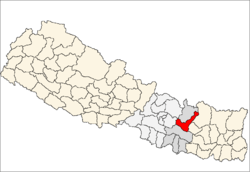 | |
| Rural municipalities |
| |
| Former VDCs |
| |
This article is issued from
Wikipedia.
The text is licensed under Creative Commons - Attribution - Sharealike.
Additional terms may apply for the media files.