Dhanwar, Giridih
| Dhanwar Rajdhanwar | |
|---|---|
| Census Town | |
 Dhanwar Location in Jharkhand, India  Dhanwar Dhanwar (India) | |
| Coordinates: 24°25′N 85°59′E / 24.42°N 85.98°ECoordinates: 24°25′N 85°59′E / 24.42°N 85.98°E | |
| Country |
|
| State | Jharkhand |
| District | Giridih |
| Population (2016) | |
| • Total | 5,00,000 |
| Languages | |
| • Official | Hindi |
| Time zone | UTC+5:30 (IST) |
| 06554 | 825412 |
| Vehicle registration | JH-11 |
| Website |
giridih |
Dhanwar is a census town in Dhanwar CD Block in subdivision of Giridih district of the Indian state of Jharkhand.
Geography
Dhanwar is located at 24°25′N 85°59′E / 24.42°N 85.98°E.[1] It has an average elevation of 336 metres (1102 feet). It has a dam called "Naulakha Dam" where many people come here for celebrating the picnic. Khorimahua (Rajdhanwar) sub-division has five block. These blocks are Rajdhanwar, Jamua, Gawan, Tisri and Deori.
Police station
Dhanwar police station has jurisdiction over Dhanwar CD Block.[2]According to old British records, Dhanwar PS was there after Giridh subdivision was formed in 1870.[3]
CD Block HQ
The headquarters of Dhanwar CD Block are located at Dhanwar.[4][5]
Demographics
As per 2011 Census of India Dhanwar had a population of 18,000. There were 9500 males and 8,500 females. Scheduled Castes numbered 698 and Scheduled Tribes numbered 6.[6]
As per 2001 India census,[7] Dhanwar had a population of 7,935. Males constitute 51% of the population and females 49%. Dhanwar has an average literacy rate of 64%, higher than the national average of 59.5%; male literacy is 73% and, female literacy is 55%. In Dhanwar, 16% of the population is under 6 years of age.
Literacy
As of 2011 census, the total number of literates in Dhanwar was 16,893 out of which 8763 were males and 8130 were females.[6]
Education
Adarsh College was established at Rajdhanwar in 1973, with the efforts of the local people of the area under the leadership of Punit Roy, former MLA. It offers bachelor’s courses in arts, science and commerce.[8]
Culture
Temple
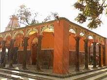
Jharkhand Dham - It is situated approximately 55 km from Giridih and 10 km from Rajdhanwar. "Jharkhand Dham" which is considered to be the second most worshipped temple of "Shiva", after Baidhnath Dham in Deoghar.
Hanuman Mandir- it is situated at Bada Chowk (cinema road) 3 km from Dhanwar station.
Shani dev Naugraha Mandir - It is recently built only temple of Shani dev in the whole district. It is situated near the Rajghat.
Chhat Puja
This town is very famous for "Chath" puja in jharkhand state. Every year, around 4 lakh people visit Dhanwar chath ghat called "Rajghat" during chath. Decoration of Rajghat occurs at huge level, which fascinates the visitors.
Economy
Rajdhanwar is a place for business at basic level. it has become a huge market place where the daily transaction are into millions, major contribution being from sale of food products, cloth, jewellery, and metals.
Banks
- State Bank of India
- Bank of India
- Jharkhand Gramin Bank
- Jharkhand State Co-operative Bank,
ATMs - Bank Of India : Two SBI - One Axis Bank - One
Healthcare
Refral Hospital(Govt. Hospital) It is the government hospital situated in Block Campus, Gandhi Chowk. Normal operations are done here.
Ayurveda Centres
- Arogya Vatika (Maharshi Patanjali Path, Manihari Chowk, Rajdhanwar) - It is one of the best known ayurvedic clinic in Jharkhand. Patients from all over India visit and get impeccable treatment. The institution has specialisation in Arthritis, Gastric, Lungs infection, blood pressure, menstrual problem and many more.
References
- ↑ Falling Rain Genomics, Inc - Dhanwar
- ↑ "District Statistical Handbook, Giridih". Tables 2.1, 2.4. Directorate of Economics and Statistics, Department of Planning and Development, Jharkhand. Retrieved 28 November 2017.
- ↑ "District Census Handbook Giridih, 2011, Series 21, Part XII A" (PDF). Pages 5-7. Directorate of Census Operations, Jharkhand. Retrieved 2 December 2017.
- ↑ "2011 District Census Handbook Giridih, Series 21, Part XII B" (PDF). Map on Page 3. Directorate of Census Operations, Jharkhand. Retrieved 28 November 2017.
- ↑ "Giridih". District Administration, Giridih. Retrieved 28 November 2017.
- 1 2 "C.D. Block Wise Primary Census Abstract Data(PCA)". Jharkhand – District-wise CD Blocks. Registrar General and Census Commissioner, India. Retrieved 8 November 2015.
- ↑ "Census of India 2001: Data from the 2001 Census, including cities, villages and towns (Provisional)". Census Commission of India. Archived from the original on 2004-06-16. Retrieved 2008-11-01.
- ↑ "Adarsh College, Raj Dhanwar". AC. Retrieved 2 December 2017.