Raijinyama Kofun
| 雷神山古墳 | |
 | |
 Raijinyama Kofun  Raijinyama Kofun (Japan) | |
| Location | Natori, Miyagi, Japan |
|---|---|
| Region | Tōhoku region |
| Coordinates | 38°09′3.2″N 140°52′46″E / 38.150889°N 140.87944°E |
| Type | kofun |
| History | |
| Founded | late 4th or early 5th century AD |
| Periods | Kofun |
| Site notes | |
| Excavation dates | 1976-1977 |
| Ownership | National Historic Site |
| Public access | Yes |
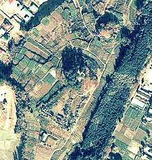
Raijinyama Kofun (雷神山古墳) is a kofun burial mound located approximately two kilometers south of the center of the city of Natori, Miyagi in the Tōhoku region of northern Japan. The site is a double mound, consisting of a large keyhole-shaped kofun with a smaller adjacent circular kofun. Both were collectively designated a National Historic Site in 1956.[1]
The tomb does not appear in any historical records and the name of rank of the person buried within is unknown. It has only been partially excavated; however, From the style of the mound and haniwa and pottery fragments discovered at the site, archaeologists have dated the kofun to the late 4th or early 5th century AD.
Raijinyama kofun
- Total length: 168 meters
- Circular Portion: 3-stages, 96 meter diameter x 12 meter height
- Keyway Portion: 72 meter length x 96 meter max width, 6 meter height, 2-stage
Kozuka kofun
- Circular Portion: 3-stages, 54 meter diameter
See also
References
- ↑ "雷神山古墳 らいじんやまこふん" [Raijinyama kofun] (in Japanese). Agency for Cultural Affairs.
External links
| Wikimedia Commons has media related to Raijin-yama Kofun. |
- MIyagi Prefecture official home page (in Japanese)
- Natori city official nome page (in Japanese)
- Natori tourism association home page (in Japanese)
This article is issued from
Wikipedia.
The text is licensed under Creative Commons - Attribution - Sharealike.
Additional terms may apply for the media files.