Raesfeld
| Raesfeld | |||
|---|---|---|---|
| |||
 Raesfeld Location of Raesfeld within Borken district 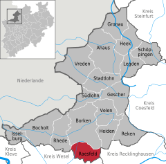  | |||
| Coordinates: 51°46′N 6°50′E / 51.767°N 6.833°ECoordinates: 51°46′N 6°50′E / 51.767°N 6.833°E | |||
| Country | Germany | ||
| State | North Rhine-Westphalia | ||
| Admin. region | Münster | ||
| District | Borken | ||
| Government | |||
| • Mayor | Andreas Grotendorst (CDU) | ||
| Area | |||
| • Total | 57.81 km2 (22.32 sq mi) | ||
| Elevation | 59 m (194 ft) | ||
| Population (2016-12-31)[1] | |||
| • Total | 11,362 | ||
| • Density | 200/km2 (510/sq mi) | ||
| Time zone | CET/CEST (UTC+1/+2) | ||
| Postal codes | 46348 | ||
| Dialling codes | 0 28 65 | ||
| Vehicle registration | BOR | ||
| Website | www.gemeinde-raesfeld.de | ||

Raesfeld (German pronunciation: [ˈʁaːsfɛlt]) is a municipality in the district of Borken in the state of North Rhine-Westphalia, Germany. It is located approximately 10 km south of Borken and 30 km east of the Dutch border. Raesfeld's landmark is the water castle at the edge of town, built in the 13th century.
Gallery
 Raesfeld, tower: Schloss Raesfeld
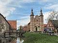 Raesfeld, on castle: Schloss Raesfeld
 Raesfeld, sculpture Kappes Anna
 Erle, church in the street
References
- ↑ "Amtliche Bevölkerungszahlen" (in German). Landesbetrieb Information und Technik NRW. Retrieved 2018-02-24.
External links
- Site of the municipality (in German)
- History of the castle (in German)
- Gallery about Raesfeld in general, and the castle (in German)
- Gallery showing the Castle
| Wikimedia Commons has media related to Raesfeld. |
Towns and municipalities in Borken (district) | ||
|---|---|---|
This article is issued from
Wikipedia.
The text is licensed under Creative Commons - Attribution - Sharealike.
Additional terms may apply for the media files.