Heek, Germany
| Heek | |||
|---|---|---|---|
| |||
 Heek Location of Heek within Borken district 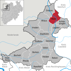  | |||
| Coordinates: 52°07′00″N 07°05′59″E / 52.11667°N 7.09972°ECoordinates: 52°07′00″N 07°05′59″E / 52.11667°N 7.09972°E | |||
| Country | Germany | ||
| State | North Rhine-Westphalia | ||
| Admin. region | Münster | ||
| District | Borken | ||
| Government | |||
| • Mayor | Franz-Josef Weilinghoff (Ind.) | ||
| Area | |||
| • Total | 68.98 km2 (26.63 sq mi) | ||
| Elevation | 50 m (160 ft) | ||
| Population (2016-12-31)[1] | |||
| • Total | 8,491 | ||
| • Density | 120/km2 (320/sq mi) | ||
| Time zone | CET/CEST (UTC+1/+2) | ||
| Postal codes | 48619 | ||
| Dialling codes | 0 25 68 | ||
| Vehicle registration | BOR | ||
| Website | www.heek.de | ||


Heek is a municipality in the district of Borken, in North Rhine-Westphalia, Germany. It is located near the border with the Netherlands, approx. 20 km south-east of Enschede. Heek consists of two villages, Heek and Nienborg.
Sights
The municipality has various sights to offer:
- Nienborg Castle
- Saint Ludgerus Church in Heek. In 1256, this catholic church was mentioned in a document for the first time. It was enlarged several times. The church houses various masterpieces of art, e.g. a baroque pulpit dating from 1755 and a medieval tabernacle from 1520.
- In the middle of Heek, Eppingscher Hof, a historic farm house dating from 1857, was transformed into a cultural center in 1990.
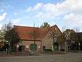 Historic farm used as a cultural center.
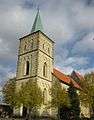 Saint Ludgerus Church.
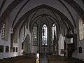 Saint Ludgerus Church, interior.
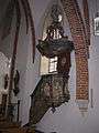 Saint Ludgerus Church, pulpit.
 Saint Ludgerus Church, tabernacle.
References
| Wikimedia Commons has media related to Heek. |
- ↑ "Amtliche Bevölkerungszahlen" (in German). Landesbetrieb Information und Technik NRW. Retrieved 2018-02-24.
This article is issued from
Wikipedia.
The text is licensed under Creative Commons - Attribution - Sharealike.
Additional terms may apply for the media files.