Racket Ridge, Arkansas
| Racket Ridge, Arkansas | |
|---|---|
| Ghost town | |
 Racket Ridge, Arkansas | |
| Coordinates: 35°32′48″N 92°38′46″W / 35.54667°N 92.64611°WCoordinates: 35°32′48″N 92°38′46″W / 35.54667°N 92.64611°W | |
| Country | United States |
| State | Arkansas |
| County | Van Buren |
| Elevation | 1,332 ft (406 m) |
| GNIS feature ID | 68691[1] |
Racket Ridge is a ghost town in Van Buren County, Arkansas, United States. Racket Ridge is located 2.2 miles (3.5 km) west-northwest of Scotland.
References
Municipalities and communities of Van Buren County, Arkansas, United States | ||
|---|---|---|
| Cities | 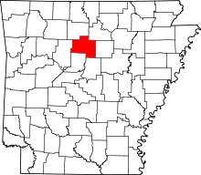 | |
| Towns | ||
| CDP | ||
| Townships |
| |
| Unincorporated communities | ||
| Ghost town | ||
| Footnotes | ‡This populated place also has portions in an adjacent county or counties | |
This article is issued from
Wikipedia.
The text is licensed under Creative Commons - Attribution - Sharealike.
Additional terms may apply for the media files.