RCAF Station Pennfield Ridge
| RCAF Station Pennfield Ridge | |||||||||||
|---|---|---|---|---|---|---|---|---|---|---|---|
| Near Chatham, New Brunswick in Canada | |||||||||||
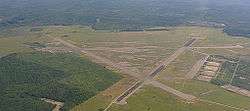 RCAF Station Pennfield Ridge - 2014 | |||||||||||
 RCAF Station Pennfield Ridge | |||||||||||
| Coordinates | 45°07′38″N 66°41′40″W / 45.12722°N 66.69444°W | ||||||||||
| Site information | |||||||||||
| Owner | Dept of National Defence (Canada) | ||||||||||
| Site history | |||||||||||
| Built | 1940 | ||||||||||
| In use | 1941-1950 | ||||||||||
| Airfield information | |||||||||||
| Elevation | 240 feet (73 m)[1] AMSL | ||||||||||
| |||||||||||
| Airfields | |||||||||||
| RCAF Station Pennfield Ridge |
|---|
RCAF Station Pennfield Ridge was a Royal Canadian Air Force training station located in coastal Charlotte County, New Brunswick in the hamlet of Pennfield Ridge.
History
Construction of the aerodrome began in the summer of 1940 after a suitable site was selected on a ridge high above the surrounding coastal plain of the north shore of the Bay of Fundy, east of the town of St. George. Proximity to a Canadian Pacific Railway line running between St. Stephen and Saint John eased the transport of building materials. General contractor Dexter Construction had 200 workers on the project by August 1940 and the runways were finished by November. The base was located southwest of the Camp Utopia, an army training facility for southwestern New Brunswick.
The first test flights took place on January 1, 1941 and the base officially opened on July 21 of that year, housing No. 2 Air Navigation School (ANS) and later No. 34 Operational Training Unit (OTU), under the command of the No. 3 Training Command, which was headquartered in Montreal as part of the British Commonwealth Air Training Plan (BCATP).[2]
By the end of summer 1941, over 40 buildings were constructed on the base, including 4 large hangars, an observation tower, barracks, drill hall, mess halls and classrooms, along with a water supply and internal telephone system. The three runways were lengthened in the fall of 1941 into the classic BCATP triangle arrangement.
The airfield was decommissioned by the RCAF toward the end of World War II, with air force activities in eastern Canada being concentrated at RCAF Station Greenwood, RCAF Station Debert, RCAF Station Summerside and RCAF Station Chatham. The Pennfield Ridge base became the operational location for Heavy Transport until it was purchased several years later and operated by a commercial airline company as an alternative to the inadequate airport serving Saint John at Millidgeville.
After the new Saint John Airport was opened in the early 1950s, Pennfield Ridge closed as an operational airfield. One of its runways was used as a drag racing track by the New Brunswick Drag Racing Association during the 1950s-1970s. Today, 2 of the 3 runways are used for drying seaweed which is then marketed as a natural plant fertilizer. The remaining runway is still able to handle small aircraft under visual flight rules (VFR) conditions; there is a small fuel reserve tank for the use of J.D. Irving Limited and New Brunswick Department of Natural Resources aircraft.
Less than 2 km (1.2 mi) to the east of the airfield is the location of the Jim Mollison landing in August 1932, in which Mollison completed the first solo east-to-west transatlantic flight. His aircraft was a de Havilland Puss Moth (G-ABXY) dubbed "The Heart's Content".
On 24 September 2006, a memorial was erected at a nearby park in Pennfield by "The Charlotte County War Memorial Committee" to honour the sixty men that died while on training at Pennfield Ridge.
Subsequent research by Pennfield Parish Military Historical Society shows that they are seventy men who died while training at Pennfield Ridge. There was also six civilian casualties as well.
Aerodrome Information
In approximately 1942 the aerodrome was listed at 45°08′N 66°41′W / 45.133°N 66.683°W with a Var. 22 degrees W and elevation of 240 feet (73 m). Three runways were listed as follows:[1]
| Runway Name | Length | Width | Surface |
|---|---|---|---|
| 3/21 | 5,010 feet (1,527 m) | 150 feet (46 m) | Hard surfaced |
| 15/33 | 4,980 feet (1,518 m) | 150 feet (46 m) | Hard surfaced |
| 9/27 | 5,085 feet (1,550 m) | 150 feet (46 m) | Hard surfaced |
References
- 1 2 3 4 5 Staff writer (c. 1942). Pilots Handbook of Aerodromes and Seaplane Bases Vol. 1. Royal Canadian Air Force. p. 47.
- ↑ Hatch, F. J. (1983). The Aerodrome of Democracy: Canada and the British Commonwealth Air Training Plan, 1939-1945. Ottawa: Directorate of History, Department of National Defence. ISBN 0660114437.
External links
- Pennfield Parish Military Historical Society – Professional research since 1989. The former track director for "Pennfield Dragway" (1989-1996) is conducting an intensive research project into the former Air Station. This website serves as a tribute to those who served there.
- Pennfield Parish Military Historical Society Blog - A blog dedicated to keep people updated to the ongoing research by Pennfield Parish Military Historical Society to preserve the rich history of Pennfield Ridge Air Station and A-30 Canadian Infantry Training Centre (Camp Utopia).
Coordinates: 45°07′38″N 066°41′40″W / 45.12722°N 66.69444°W