Rába
| Rába | |
|---|---|
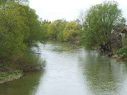 The Rába at Molnaszecsőd | |
| Country | Austria, Hungary |
| Physical characteristics | |
| Main source |
Austrian Alps (Teichalm) 1,150 m (3,770 ft) |
| River mouth |
Danube (Mosoni Duna branch), Győr 47°41′03″N 17°38′04″E / 47.68417°N 17.63444°ECoordinates: 47°41′03″N 17°38′04″E / 47.68417°N 17.63444°E |
| Length | 298.2 km (185.3 mi) [1] |
| Discharge |
|
| Basin features | |
| Progression | Danube→ Black Sea |
| Basin size | 14,968 km2 (5,779 sq mi) |
| Tributaries | |
The Rába (German: Raab; Hungarian: Rába; Slovene: Raba [ˈɾáːba][2]) is a river in southeastern Austria and western Hungary and a right tributary of the Danube. Its source is in Austria, some kilometres east of Bruck an der Mur below Heubodenhöhe Hill. It flows through the Austrian states of Styria and Burgenland, and the Hungarian counties of Vas and Győr-Moson-Sopron. Its is 298.2 km (185.3 mi) long, of which about 100 km in Austria.[1] It flows into a tributary of the Danube (Mosoni-Duna) in northwestern Hungary, in the city of Győr. Towns along the Rába include Gleisdorf, Feldbach (both in Austria), and Szentgotthárd and Körmend (in Hungary). In the early Cenozoic the river used to flow in the opposite direction, but tectonic uplift reversed this flow.
The Rába Slovenes, living in the Rába Valley (Sln. Porabje, Hung. Vendvidék), are the westernmost group of Hungarian Slovenes. The Raba Valley is part of the wider region of Prekmurje.[3]
References
- 1 2 Digitaler Atlas der Steiermark (Styria)
- ↑ "Slovenski pravopis 2001: Raba".
- ↑ "Slovenians in Hungary". Ministry of Foreign Affairs, Government of Slovenia. Retrieved 11 February 2011.