Quinto, Aragon
| Quinto | |||
|---|---|---|---|
| Town and municipality | |||
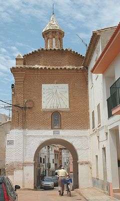 San Roque towngate in Quinto | |||
| |||
| Country | Spain | ||
| Autonomous community | Aragon | ||
| Province | Zaragoza | ||
| Municipality | Quinto | ||
| Area | |||
| • Total | 118.4 km2 (45.7 sq mi) | ||
| Elevation | 175 m (574 ft) | ||
| Population (2017) | |||
| • Total | 1,960 | ||
| • Density | 16.55/km2 (42.9/sq mi) | ||
| Time zone | UTC+1 (CET) | ||
| • Summer (DST) | UTC+2 (CEST) | ||


Quinto (Spanish pronunciation: [ˈkinto]) is a town and municipality in the province of Zaragoza, northeast Spain. It is located on the south bank of the river Ebro about 41 km south-east of Zaragoza, capital city of Aragon. In 2017 its population was 1,960 (INE 2017), with an area of 118.40 km². Quinto is the capital of the comarca (county) of Ribera Baja del Ebro.
Geography
Location
The municipality of Quinto is located in the Ebro Basin at 175 metres (574 feet) above sea level, on Quaternary deposits near the river Ebro. It is at a distance of 42 km from Zaragoza, capital city of the province and the autonomous community of Aragon.
Clima
According to the Köppen climatic classification, Quinto has a cold semi-arid climate (type BSk). The winters are slightly cold, with possible night frosts, and in December and January fog and temperature inversions are common. Summers are warm, with maximums above 30 °C, which usually pass 35 °C; the minimums are usually less than 20 °C. The wind called Cierzo can be strong at any season, especially from October to April. Precipitation surpasses scarcely the 300 annual mm, concentrating in spring and autumn, and winter and summer are dry. Snowfalls are unusual.[1]
History
Name
The name Quinto derives from the Latin word quintus, meaning "the fifth". It referred to the fifth milestone of the Roman road from Celsa (Velilla de Ebro) to Caesar Augusta (Zaragoza). It seems like the Roman administration set up some kind of military service around that mile marker, being that the origin of the settlement.[2]
Early history
In the place called Las Dehesas, on the cliffs that dominate the river Ebro as it passes through the bridge of Gelsa, there is a settlement of the Early Iron Age. Its chronology covers approximately from 750 to 500 BCE, at which time it was totally destroyed by fire. The site is practically destroyed by some works carried out by Renfe.
The urban structure, with elongated rectangular house plans, corresponds to the classic schemes of this type of town in the middle Ebro Valley. The cereal grains, the remains of hand mills and Spengler's freshwater pearl mussel shells… they imply that the economy of the settlement was based on agriculture and husbandry, although accompanied by the collection of some wild products directly from nature.[3]
Late modern period
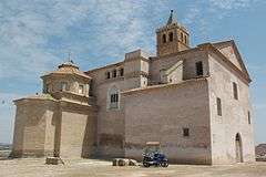
During the Battle of Belchite in 1937 during the Spanish Civil War, Spanish Republican forces including the British Battalion of XV International Brigade captured the village from the Nationalists. Fierce house-to-house fighting destroyed many buildings, including the historic church of la Asunción de Nuestra Señora (Assumption of Our Lady) overlooking the village. The church, with its Mudéjar tower, has recently been restored.[4]
See also
References
- ↑ Atlas climático de Aragón. López Martín, Fernando., Cabrera Millet, Matilde., Cuadrat, José María., Saz Sánchez, M. A., Vicente Serrano, Sergio Martín. [Zaragoza]: Servicio de Información y Educación Ambiental, Dirección General de Calidad Ambiental y Cambio Climático. 2007. ISBN 9788483800713. OCLC 433634972.
- ↑ "Historia | Quinto". Quinto (in Spanish). Retrieved 2018-10-08.
- ↑ SL, DiCom Medios. "Gran Enciclopedia Aragonesa Online". www.enciclopedia-aragonesa.com (in Spanish). Retrieved 2018-10-08.
- ↑ Aragon Government – DECRETO 224/2001+ de 18 de septiembre, del Gobierno de Aragón, por el que se declara bien de Interés Cultural, en la categoría de Monumento, la denominada Iglesia de la Asunción de Nuestra Señora de Quinto de Ebro (Zaragoza)
External links
| Wikimedia Commons has media related to Quinto. |
- Quinto Web Site – History, places, photos
- Quinto Town Hall – Official Site
- Birdwatching in Monegros, Belchite steppes, Planeron, Quinto
Coordinates: 41°25′19″N 0°29′55″E / 41.42194°N 0.49861°E