Quail Island (New Zealand)
| Ōtamahua (Māori) | |
|---|---|
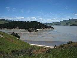 A view from Quail Island at low tide. The small King Billy Island is seen in front of the wooded peninsula. | |
| Geography | |
| Coordinates | 43°38′S 172°41′E / 43.63°S 172.69°E |
| Highest elevation | 86 m (282 ft) |
| Administration | |
| Demographics | |
| Population | nil |
Quail Island (Ōtamahua in Māori, sometimes also known as Te Kawakawa) is a small uninhabited island within Lyttelton Harbour in the South Island of New Zealand, close to Christchurch. The island was given its European name by Captain William Mein Smith who saw native quail here in 1842; though they were already extinct by 1875. 'Ōtamahua' has the meaning of a 'place where children collect sea eggs'.[1] 'Te Kawakawa' refers to the pepper trees found on the island.[2]
History
Apparently uninhabited by the New Zealand native peoples, it was still often visited to collect shellfish, flax, bird's eggs as well as stone for tools (from King Billy Island, an outcrop just off Quail Island). Europeans briefly farmed it in 1851, before it was turned into a quarantine station in 1875, and later into a small leper colony from 1907 to 1925, while being used as a hospital during the influenza epidemic of 1907.[1]
Replicas of dog kennels (once used for training of the dogs used in Antarctic expeditions of the early 20th century) and a replica leprosy patient's hut were built by students of Cathedral College, with the quarantine barracks also restored and moved to the beach front. Subantarctic explorations that used Quail Island were the Discovery Expedition (1901–04), Nimrod Expedition (1907–09), Terra Nova Expedition (1910–13), and the Byrd Antarctic Expedition (1928–30).[3] The island was declared a recreation reserve in 1975, but was also farmed (potatoes) until the early 1980s by David Helliwell who also acted as the island's caretaker. This island has a number of safe swimming beaches, as well as some day facilities (toilets, day shelter). A ferry service is available to the island, and private watercraft may also access the island. A man called Ivon Skelton was buried on the island on 22 October 1923, and this is the island's only grave.[1]
Ecological restoration
The Ōtamahua/Quail Island Ecological Restoration Trust and the Department of Conservation are currently working to remove pests and re-vegetate the island, with the aim of eventually re-introducing native wildlife.[1][4]
The Ōtamahua/Quail Island Ecological Restoration Trust aims to restore 24 hectares (59 acres) of native forest to the island to provide a refuge for locally extinct, uncommon and threatened bird and invertebrate species of the Banks Peninsula region. The Trust also encourages and facilitates educational activities and relevant research on the natural features and cultural history of the island.
Quail Island is the only substantial island in the Canterbury area accessible to the public. Community volunteers have been transformed large areas of the island from dry and desolate pest-ridden areas to a safe haven for indigenous species. The project is unique in the way it balances the recreational use and historical features of Quail Island while re-establishing the native ecosystems, both flora and fauna. Penguin nesting boxes have also been established on the island to provide a safe nesting site for the white-flippered penguin, an endangered Banks Peninsula native. The Trust organises fortnightly work parties on the island to undertake animal and weed pest control. An annual planting is undertaken each spring.
The Trust's volunteers have planted more than 95,000 native trees and shrubs, established a nursery to propagate silver tussock, and eradicated all predators except mice. As a result, birds, invertebrates and rare plants have been reintroduced to the island. This includes bellbirds and kereru as well as Lepidium aegrum (Banks Peninsula scurvy grass), a "nationally critical" plant. Many schools and groups now visit the island to combine outdoor activities with their studies of the natural environment.
See also
Further reading
- Jackson, Peter (2006). Ōtamahua/Quail Island : a link with the past (2nd ed.). Christchurch: Chaucer Press Ltd.
References
- 1 2 3 4 Ōtamahua/Quail Island Recreation Reserve (from the Department of Conservation website)
- ↑ Otamahua (from the Christchurch City Libraries website)
- ↑ "Quail Island, Lyttelton used by Antarctic expeditions". Ministry for Culture and Heritage. 19 September 2014. Retrieved 24 November 2015.
- ↑ Patrick, H.J.H.; Bowie, M.H.; Fox, B.W.; Patrick, B.H. (2011). "The moths of Quail Island (Otamahua): a faunal comparison of an island under restoration with other sites on Banks Peninsula" (PDF). New Zealand Natural Sciences Journal. 36: 57–72.
External links
| Wikimedia Commons has media related to Quail Island. |
- Department of Conservation – Ōtamahua/Quail Island Recreation Reserve
- Ōtamahua/Quail Island Ecological Restoration Trust – Quail Island Ecological Restoration Trust