Quản Bạ District
| Quan Ba District Huyện Quản Bạ | |
|---|---|
| Rural district | |
 | |
| Country |
|
| Region | Northeast |
| Province | Ha Giang |
| Capital | Tam Sơn |
| Area | |
| • Total | 210 sq mi (550 km2) |
| Population (2003) | |
| • Total | 39,821 |
| Time zone | UTC+7 (UTC + 7) |
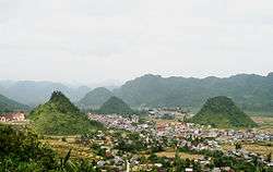
Quản Bạ is a rural district of Ha Giang province in the Northeast region of Vietnam. As of 2003, the district had a population of 39,821.[1] The district covers an area of 550 km². The district capital lies at Tam Sơn.[1]
Administrative divisions
Tam Sơn, Thái An, Lùng Tám, Đông Hà, Quản Bạ, Quyết Tiến, Cán Tỷ, Thanh Vân, Bát Đại Sơn, Nghĩa Thuận, Cao Mã Pờ, Tùng Vài, Tả Ván.
References
- 1 2 "Districts of Vietnam". Statoids. Retrieved March 13, 2009.
| Bắc Giang Province |  | |
|---|---|---|
| Bắc Kạn Province | ||
| Cao Bằng Province | ||
| Hà Giang Province | ||
| Lạng Sơn Province | ||
| Phú Thọ Province | ||
| Quảng Ninh Province | ||
| Thái Nguyên Province | ||
| Tuyên Quang Province | ||
※ denotes provincial seat. | ||
Coordinates: 23°04′59″N 104°55′01″E / 23.083°N 104.917°E
This article is issued from
Wikipedia.
The text is licensed under Creative Commons - Attribution - Sharealike.
Additional terms may apply for the media files.