Qlaileh
| Qlaileh القليلة Leileh | |
|---|---|
| Village | |
 Qlaileh | |
| Coordinates: 33°11′47″N 35°13′52″E / 33.19639°N 35.23111°E | |
| Grid position | 171/289 PAL |
| Country |
|
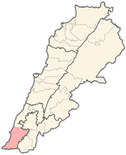
| Governorate | South Governorate |
| District | Tyre |
| Time zone | GMT +3 |
Qlaileh, Leileh, (Arabic: القليلة) is a village in the Tyre District in South Lebanon.
Name
According to E. H. Palmer in 1881, the name Leileh comes from a female proper name; it also means “night”.[1]
History
In 1875 Victor Guérin describes a ruin here, which he calls Kh. Kleileh. The upright of oil-presses, a winepress cut in the rock, with two compartments, one round and one square, and three broken sarcophagi, are all that remain here. A short distance south of this place he found another ruined hamlet, having a cistern cut in the rock, and an enormous millstone lying on the ground, called Kh. Ratieh.[2]
In 1881, the Palestine Exploration Fund's Survey of Western Palestine (SWP) described it: "A small well-built stone village, containing about 50 Moslems, surrounded by olives and arable ground. The water supply is from 'Ain Zaheiriyeh."[3]
References
Bibliography
- Conder, C.R.; Kitchener, H.H. (1881). The Survey of Western Palestine: Memoirs of the Topography, Orography, Hydrography, and Archaeology. 1. London: Committee of the Palestine Exploration Fund.
- Guérin, V. (1880). Description Géographique Historique et Archéologique de la Palestine (in French). 3: Galilee, pt. 2. Paris: L'Imprimerie Nationale.
- Palmer, E.H. (1881). The Survey of Western Palestine: Arabic and English Name Lists Collected During the Survey by Lieutenants Conder and Kitchener, R. E. Transliterated and Explained by E.H. Palmer. Committee of the Palestine Exploration Fund.
External links
- Qlaileh, Localiban
- Survey of Western Palestine, Map 1: IAA, Wikimedia commons
Capital: Tyre | ||
| Towns and villages |
|  |