Qillqata (Arequipa-Moquegua)
| Qillqata | |
|---|---|
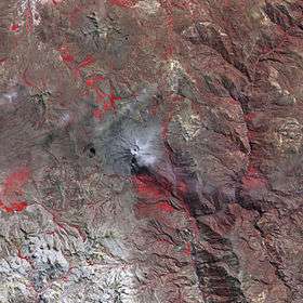 The Ubinas volcano and Qillqata southwest of it (lower left) as seen from above (NASA, 2006) | |
| Highest point | |
| Elevation | 5,200 m (17,100 ft) [1] |
| Coordinates | 16°29′55″S 71°00′46.5″W / 16.49861°S 71.012917°WCoordinates: 16°29′55″S 71°00′46.5″W / 16.49861°S 71.012917°W |
| Geography | |
 Qillqata Peru | |
| Location | Peru, Arequipa Region, Arequipa Province, Moquegua Region, General Sanchez Cerro Province |
| Parent range | Andes |
Qillqata (Aymara qillqaña to write,[2] -ta a suffix to indicate the participle, "written" or "something written", hispanicized Quelcata) is a mountain in the Andes of Peru, about 5,200 metres (17,060 ft) high. It is located southeast of Lake Salinas in the Arequipa Region, Arequipa Province, Tarucani District, and in the Moquegua Region, General Sánchez Cerro Province, Coalaque District. Some of the highest mountains near Qillqata are Wilani in the northeast, Q'uwa Laki in the southeast and Pachakutiq.[1]
See also
References
- 1 2 escale.minedu.gob.pe - UGEL map of the General Sánchez Cerro (Moquegua Region)
- ↑ Radio San Gabriel, "Instituto Radiofonico de Promoción Aymara" (IRPA) 1993, Republicado por Instituto de las Lenguas y Literaturas Andinas-Amazónicas (ILLLA-A) 2011, Transcripción del Vocabulario de la Lengua Aymara, P. Ludovico Bertonio 1612 (Spanish-Aymara-Aymara-Spanish dictionary)
This article is issued from
Wikipedia.
The text is licensed under Creative Commons - Attribution - Sharealike.
Additional terms may apply for the media files.