Pachakutiq (Arequipa-Moquegua)
| Pachakutiq | |
|---|---|
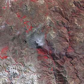 The Ubinas volcano and Pachakutiq southwest of it (lower left) as seen from above (NASA, 2006) | |
| Highest point | |
| Elevation | 5,173 m (16,972 ft) [1] |
| Coordinates | 16°27′18″S 71°2′47″W / 16.45500°S 71.04639°WCoordinates: 16°27′18″S 71°2′47″W / 16.45500°S 71.04639°W |
| Geography | |
 Pachakutiq Peru | |
| Location | Peru, Arequipa Region, Arequipa Province, Moquegua Region, General Sánchez Cerro Province |
| Parent range | Andes |
Pachakutiq (Quechua pacha time, space, kuti return, "return of time", "change of time", pacha kuti "great change or disturbance in the social or political order", -q a suffix,[2] Pachakutiq an Inca emperor, Hispanicized spelling Pachacutec) is a 5,173-metre-high (16,972 ft) mountain in the Andes of Peru. It is located southeast of Lake Salinas in the Arequipa Region, Arequipa Province, Tarucani District, and in the Moquegua Region, General Sánchez Cerro Province, Coalaque District. Pachakutiq lies northwest of Q'uwa Laki and Qillqata.[1][3]
See also
References
- 1 2 "Cerro Pachacutec". IGN, Peru. Retrieved February 2, 2015.
- ↑ Teofilo Laime Ajacopa, Diccionario Bilingüe Iskay simipi yuyayk'ancha, La Paz, 2007 (Quechua-Spanish dictionary)
- ↑ escale.minedu.gob.pe - UGEL map of the General Sánchez Cerro Province (Moquegua Region)
This article is issued from
Wikipedia.
The text is licensed under Creative Commons - Attribution - Sharealike.
Additional terms may apply for the media files.