Punta Gorda, Montevideo
Panopuntagorda.jpg
| Punta Gorda | |
|---|---|
| Barrio | |
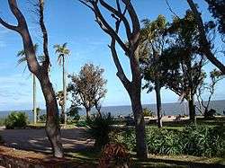 Plaza de la Armada | |
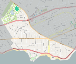 Street map of Punta Gorda | |
 Location of Punta Gorda in Montevideo | |
| Coordinates: 34°53′30″S 56°4′55″W / 34.89167°S 56.08194°WCoordinates: 34°53′30″S 56°4′55″W / 34.89167°S 56.08194°W | |
| Country |
|
| Department | Montevideo Department |
| City | Montevideo |
Punta Gorda is a barrio (neighbourhood or district) of Montevideo, Uruguay. It takes its name from the promontory of Punta Gorda.
Location
It borders Malvín to the west, Las Canteras to the northwest, Carrasco Norte and Carrasco to the northeast and the coastline to the south. The coastal avenue along Punta Gorda takes on the names Rambla O'Higgins and Rambla República de Méjico, across which are the beaches Playa de los Ingleses and Playa Verde.

Punta Gorda, Montevideo
Landmarks
On top of the promontory is a square which is also a park, the Plaza de la Armada (formerly known as Plaza Virgilio) and it is a tourist hotspot. Another notable sight is the Molino de Perez, a historic watermill, now housing a cultural centre.
Educational facilities
- Colegio y Liceo Santa Rita, Toronto 1597 (private, Roman Catholic, Augustinians)[1]
Places of worship
- Parish Church of St Rita of Cascia, Friburgo 5763 (Roman Catholic, Augustinians)[2]
Gallery
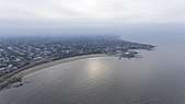 Punta Gorda beach, aerial view, Montevideo, Uruguay |
 Plaza de la Virgilio |
 Molino de Perez |
 Rambla in Punta Gorda |
See also
References
- ↑ Augustinians in Uruguay Archived 2013-03-24 at the Wayback Machine. (in Spanish)
- ↑ Augustinians in Uruguay Archived 2013-03-24 at the Wayback Machine. (in Spanish)
External links
| Wikimedia Commons has media related to Punta Gorda, Montevideo. |
This article is issued from
Wikipedia.
The text is licensed under Creative Commons - Attribution - Sharealike.
Additional terms may apply for the media files.