Atahualpa, Montevideo
| Atahualpa | |
|---|---|
| Barrio | |
 Plaza Atahualpa | |
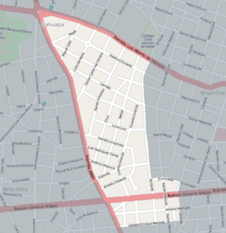 Street map of Atahualpa | |
 Map of Montevideo highlighting the barrio | |
| Coordinates: 34°51′53″S 56°11′23″W / 34.86472°S 56.18972°WCoordinates: 34°51′53″S 56°11′23″W / 34.86472°S 56.18972°W | |
| Country |
|
| Department | Montevideo Department |
| City | Montevideo |
| Website | http://www.barrioatahualpa.com/mapa.php |
Atahualpa is a barrio (neighbourhood or district) of Montevideo, Uruguay.
Location
Atahualpa shares borders with Prado to the west, Aires Puros to the north, Brazo Oriental to the east and Reducto to the south.
See also
External links
| Wikimedia Commons has media related to Atahualpa, Montevideo. |
- Comisión de Vecinos del Barrio Atahualpa
- Intendencia de Montevideo / Historia / Barrios / (see section) El paseo del Prado
- Revista Raices / Historia del barrio Atahualpa
This article is issued from
Wikipedia.
The text is licensed under Creative Commons - Attribution - Sharealike.
Additional terms may apply for the media files.