Puerto Williams
| Puerto Williams | |||||
|---|---|---|---|---|---|
| Town, port and naval base | |||||
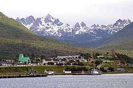 View of Puerto Williams with Dientes de Navarino mountains behind | |||||
| |||||
| Coordinates: 54°56′S 67°37′W / 54.933°S 67.617°WCoordinates: 54°56′S 67°37′W / 54.933°S 67.617°W | |||||
| Country |
| ||||
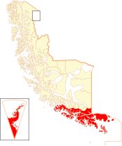
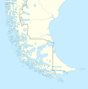
| Region |
| ||||
| Province | Antártica Chilena | ||||
| Commune | Cabo de Hornos | ||||
| Founded as | Puerto Luisa | ||||
| Founded | 21 November 1953 | ||||
| Government | |||||
| • Type | Municipality | ||||
| • Alcalde | Patricio Fernández | ||||
| Population (2002) | |||||
| • Total | 2,874 | ||||
| Time zone | UTC−3 (CLST) | ||||

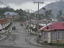
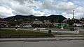
Puerto Williams (Spanish for "Port Williams") is a Chilean village, port and naval base located on Navarino Island facing the Beagle Channel. It is the capital of the Chilean Antarctic Province, one of four provinces located in the Magellan and Chilean Antarctica Region, and administers the communes of Chilean Antarctic Territory and Cabo de Hornos. It has a population of 2,874, including both naval personnel and civilians. Puerto Williams claims the title of world's southernmost city.[1][2][3][4][5][6][7]
The settlement was founded in 1953, and was first named Puerto Luisa. The town was later named for John Williams Wilson, a British man who founded Fuerte Bulnes, the first settlement in the Strait of Magellan since 1587. It has served primarily as a naval base for Chile. The Chilean Navy runs the Guardiamarina Zañartu Airport and hospital, as well as nearby meteorological stations. Since the late 20th century, the number of navy personnel have decreased in Puerto Williams and the civilian population has increased. In that period, tourism and support of scientific research have contributed to an increase in economic activity.
The port attracts tourists going to Cape Horn or Antarctica; its tourism industry developed around the concept of "the world's most southern city". Based on some definitions of what a city is, Puerto Williams could in fact be the southernmost city in the world. However, others dispute this because of the town's small size and population in favour of Ushuaia or Punta Arenas. Chilean and Argentinian media, a bilateral agreement between Chile and Argentina, and the Puerto Williams administration identify it as the southernmost city in the world.[3][4][8][5][6]
Puerto Williams is the port of entry and major hub for scientific activity linked to Antarctica and the islands south of Isla Grande de Tierra del Fuego. The University of Magallanes has a university centre in Puerto Williams. Weather stations and lighthouses at Cape Horn and Diego Ramírez Islands are supplied from Puerto Williams. The town has been a base for Chile to assert sovereignty around Cape Horn and support its Antarctic bases.
Puerto Williams also serves as provision and service centre for fishermen. The Navy is based here in part to enforce national fishing rights in the exclusive economic zone around the southern part of Tierra del Fuego, where lucrative lithodes santolla fishing is an important industry.
History
The Yahgan people, indigenous to southern Chile, are believed to have migrated to this area more than 10,000 years ago and established their traditional hunter-gatherer culture. Europeans first came across them and the area in the early sixteenth century. It was not until the 19th century that Europeans began to be interested in the area for development; its towns had sometimes supplied whaling ships.
At the end of the 19th century, gold was discovered in the region, attracting masses of migrants and immigrants seeking fortunes. By 1890 there were approximately 300 goldminers in the Picton, Lennox and Nueva islands and Puerto Toro which was founded in 1892.[9] Puerto Navarino, on the west side of the Navarino island, was founded in June 1938. In addition, some of the islands were developed to support sheep ranching, and meat and wool exports became important.
Puerto Williams was founded 1953, developed primarily as a naval base for Chile. Its naval hospital of 463 m2 (today 638 m2) opened in 1960.[10] In 2002 the electrical power supply was transferred from the Chilean Navy to a private provider.[11]
According to the Treaty of Peace and Friendship of 1984 between Chile and Argentina, Puerto Williams is the start point for vessels of all nations in traffic between the Straits of Magellan and Argentine ports in the Beagle Channel.
Demography
Between 1982 and 2002, the population of Puerto Williams grew from 1,059 to 2,874.[12] Since 1982, Puerto Williams has been classified as an urban entity by Chile's National Statistics Institute (INE),[12] although the department generally classifies a city as an urban entity with more than 5,000 residents.[13][14]
Local celebrations
Glorias Navales Regata: In the last week of May, the city holds a sailing competition attracting international participants. The competition is on its 7th season and has more than 300 participants every year. The journey starts from the city's port and takes the fjords route. The regatta is part of the Chilean Navy's Month of the Sea activities that commemorate the Naval Battle of Iquique in 1879.
Fiesta de la nieve ("Snow Festival"): Celebrating the winter season in July, the city celebrates the winter with snow games, cars and rodeos, in a celebration that lasts 6 days.[15]
Climate
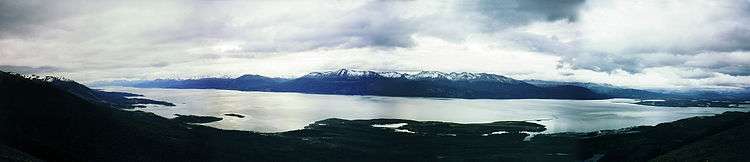
The climate of Puerto Williams is a temperate subpolar oceanic climate (Cfc) according to the Köppen climate classification. The summers are short and cool while the winters are long, wet, but moderate. Rainfall is around 512.3 mm (20 in) a year and temperatures are steady throughout the year. Snowfall can occur in summer. The cold and wet summers help preserve glaciers. Although the area around the town is well-forested, exposed areas at some distance from or altitude above it have a sub-Antarctic climate typical of tundra, which makes the growth of trees impossible. Regions in the world with similar climates to southern Tierra del Fuego include the Alexander Archipelago around Sitka in Alaska, Scotland, and the coast of Norway.
| Climate data for Puerto Williams (1977-2010) | |||||||||||||
|---|---|---|---|---|---|---|---|---|---|---|---|---|---|
| Month | Jan | Feb | Mar | Apr | May | Jun | Jul | Aug | Sep | Oct | Nov | Dec | Year |
| Record high °C (°F) | 27 (81) |
27.5 (81.5) |
25 (77) |
21.6 (70.9) |
17.5 (63.5) |
15.6 (60.1) |
17 (63) |
20 (68) |
19.8 (67.6) |
19.5 (67.1) |
26.3 (79.3) |
25.3 (77.5) |
27.5 (81.5) |
| Average high °C (°F) | 15.1 (59.2) |
14.5 (58.1) |
12.7 (54.9) |
10.1 (50.2) |
7.2 (45) |
5.2 (41.4) |
3.9 (39) |
5.8 (42.4) |
8.5 (47.3) |
9.6 (49.3) |
12.3 (54.1) |
14.5 (58.1) |
10 (50) |
| Daily mean °C (°F) | 10.5 (50.9) |
10.0 (50) |
8.8 (47.8) |
6.7 (44.1) |
3.9 (39) |
2.6 (36.7) |
1.3 (34.3) |
3.1 (37.6) |
4.6 (40.3) |
5.9 (42.6) |
7.9 (46.2) |
9.8 (49.6) |
6.3 (43.3) |
| Average low °C (°F) | 5.9 (42.6) |
5.6 (42.1) |
4.9 (40.8) |
3.2 (37.8) |
0.6 (33.1) |
0 (32) |
−1.3 (29.7) |
0.4 (32.7) |
0.6 (33.1) |
2.1 (35.8) |
3.5 (38.3) |
5.1 (41.2) |
2.6 (36.7) |
| Record low °C (°F) | −1 (30) |
−2.3 (27.9) |
−3.8 (25.2) |
−4 (25) |
−7.7 (18.1) |
−13.8 (7.2) |
−12.8 (9) |
−11 (12) |
−8.3 (17.1) |
−6.6 (20.1) |
−3 (27) |
−1.8 (28.8) |
−13.8 (7.2) |
| Average rainfall mm (inches) | 52.7 (2.075) |
28.3 (1.114) |
46.5 (1.831) |
45 (1.77) |
52.7 (2.075) |
54 (2.13) |
40.3 (1.587) |
37.2 (1.465) |
36 (1.42) |
31 (1.22) |
39 (1.54) |
49.6 (1.953) |
512.3 (20.169) |
| Average rainy days | 10 | 9 | 11 | 10 | 10 | 11 | 11 | 9 | 8 | 9 | 10 | 11 | 119 |
| Average relative humidity (%) | 79 | 79 | 77 | 82 | 93 | 87 | 86 | 83 | 79 | 75 | 74 | 74 | 79 |
| Mean monthly sunshine hours | 255.5 | 190.0 | 164.3 | 117.0 | 68.0 | 41.0 | 58.7 | 105.9 | 156.0 | 213.9 | 241.0 | 255.5 | 1,885.8 |
| Source: geodata.us[16] | |||||||||||||
Tourism
Tourism is one of the main economic activities of Puerto Williams. Most lodgings for tourists are hostels. Several trails for multi-day hikes and back-packing trips have been developed in the Dientes de Navarino mountains south of Puerto Williams. A five-day hiking circuit passes around the jagged pinnacles known as the Dientes de Navarino. The trail passes peaks known as Cerro Clem and Montes Lindenmayer, named in 2001 by the Chilean Ministry of Natural Resources for the author of the Lonely Planet guide.[17] Remains of Yahgan Indian campsites and fishtraps can be found along the coast east of the city. Puerto Williams is home to the Martin Gusinde Anthropological Museum, which depicts the lives of both the Yahgan (or Yámana) and Selk'nam peoples, who were indigenous to Tierra del Fuego. For easy exploration of some of the subantarctic forest, the Omora Ethnobotanical Park is five kilometres down the road to the west.
Transport
Access is by daily air service provided by Aerovías DAP or by the weekly vehicle ferry, Yaghan, from Punta Arenas, 350 kilometres (220 mi) to the north.[18] There is no formal public transport service, but an expensive transfer is possible using smaller boats to Ushuaia on the main island of Tierra del Fuego, in Argentina.[19]
Naval base
Puerto Williams is one of the principal naval bases of the Chilean Navy. The base is used as start point for patrol, reconnaissance missions, and rescues in the areas of Beagle Channel, Cape Horn, Drake Passage and the Antarctic Peninsula. The Chilean Navy operates Guardia Marina Zañartu Airport and the Naval Hospital of Puerto Williams in Puerto Williams. Navy personnel make up a considerable portion of the population, although their numbers have decreased in the 21st century.
The following patrol boats and ships are stationed at Puerto Williams:[20]
- PSG Sibbald
- PSG Isaza
- LSG Hallef
- LSG Alacalufe
- PM Puerto Williams
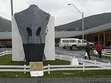
The bow section of the Yelcho, the tug used by Luis Pardo in the 20th century to rescue Ernest Shackleton's men stranded on Elephant Island, has been installed at the front of the Naval headquarters.[21]
Services and facilities
The city has a branch of Banco de Chile, and supports a fire station, and a police station of the Carabineros de Chile. Children are educated at a kindergarten, and primary and secondary schools, and a university centre of the University of Magallanes. The Martin Gusinde Anthropological Museum, an airport, seaport, and Micalvi Yacht Club are attractions.
Gallery
 O'Higgins Plaza.
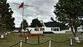 Arturo Prat Plaza.
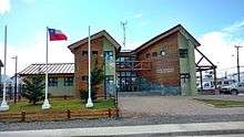 Municipality of Cabo de Hornos.
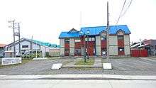 Antártica Chilena Province Governorate in Puerto Williams.
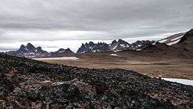 Dientes de Navarino From Cerro Bandera.
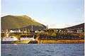 Puerto Williams from the port.
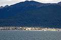 Puerto Williams from the Beagle Channel.
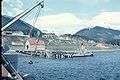 Puerto Williams in 1957.
.jpg) Catholic Church of Puerto Williams.
Catholic Church of Puerto Williams..jpg) Naval base of Puerto Williams.
Naval base of Puerto Williams. Puerto Williams from Cerro Bandera.
See also
References
- ↑ "Diario: Punto Williams", Clarin, 30 June 1998
- ↑ "Puerto Williams: ubicada entre Tierra del Fuego por el norte y el Cabo de Hornos por el sur , por lo tanto es la cuidad mas Austral del país y del mundo", Turismo Paliake
- 1 2 http://www.infinito-sur.com/ Archived 2013-04-22 at the Wayback Machine., retrieved 9 April 2012
- 1 2 "Puerto Williams espera una gran temporada de centolla", retrieved 9 April 2012
- 1 2 Escritorio Estudiantes, retrieved 9 April 2012
- 1 2 dibam, retrieved 9 April 2012
- ↑ Travel Destinations: Latin America, Times Online
- ↑ http://edant.clarin.com/diario/1998/06/30/e-04801d.htm
- ↑ Gastón Droguett Valdivia, Historia de Puerto Williams, Capital de la Provincia Antártica Chilena, retrieved on 13 April 2012
- ↑ Historia Hospital Naval de Puerto Williams Archived 2015-01-11 at the Wayback Machine., retrieved on 13 April 2012
- ↑ "1897 La luz llega a Magallanes" Archived 2015-01-11 at the Wayback Machine., Edelmag,
- 1 2 EL POBLAMIENTO RURAL EN MAGALLANES DURANTE EL SIGLO XX. REALIDAD Y UTOPÍA. Mateo Martinic. Magallania, 2006.
- ↑ "Division pol-adm" (PDF), National Statistics Institute (in Spanish), p. 10, 2001, retrieved 12 March 2011
- ↑ "División Político Administrativa" (PDF) (in Spanish). 2007. p. 351. Retrieved 12 March 2011.
- ↑ "Puerto Williams", Letsgochile.com
- ↑ "Puerto Williams Climate Data". geodata.us. March 2012. Retrieved June 17, 2011.
- ↑ Lindenmayer, C.(2003) Trekking in the Patagonian Andes Lonely Planet ISBN 978-1-86450-059-2 p.257
- ↑ "Chile opens ferry line linking Punta Arenas with Puerto Williams". Mercopress. 21 Nov 2011. Retrieved 29 December 2014.
- ↑ "Fernandez Campbell website". Archived from the original on 2014-05-27. Retrieved 2014-12-29.
- ↑ Armada de Chile, Tercera Zona Naval: Unidades Dependientes.
- ↑ John F.Mann, "The S.S. Yelcho" Archived 2012-03-06 at the Wayback Machine., Endurance obituaries website, retrieved on 15 April 2012
External links
![]()
- Information from the Chilean Tourism Service regarding activities in Puerto Williams and Cabo de Hornos National Park
- Spanish WP on Commune of Cabo de Hornos
- Puerto Williams and Commune of Cabo de Hornos official website
- Official website of Puerto Williams
- Prensa Antártica - News of the Antártica Chilena Province
- Museo Antropológico Martín Gusinde
- Cape Horn Biosphere Reserve