Dientes de Navarino
| Dientes de Navarino | |
|---|---|
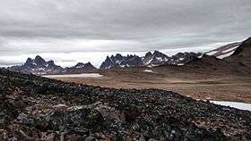 View of Dientes de Navarino from Cerro Bandera on February 14 (summer), 2016 | |
| Highest point | |
| Peak | Pico Navarino |
| Elevation | 1,195 m (3,921 ft) |
| Dimensions | |
| Length | 30 km (19 mi) north-south |
| Geography | |
| Country | Chile |
| State/Province | Magallanes |
| Range coordinates | 55°1′S 67°39′W / 55.017°S 67.650°WCoordinates: 55°1′S 67°39′W / 55.017°S 67.650°W |
| Parent range | Andes |
Dientes de Navarino (Teeth of Navarino in English) are a mountain range in Navarino Island, Chile, located just south of Puerto Williams, along the Beagle Channel coast. They are named for the jagged pinnacles which resemble teeth.
There is a rough hiking circuit around the range. Depending on weather conditions the trek takes 5 to 7 days. The trail passes peaks known as Cerro Clem and Montes Lindenmayer, named in 2001 by the Chilean Ministry of Natural Resources for the author of the Lonely Planet guide. [1]
See also
References
This article is issued from
Wikipedia.
The text is licensed under Creative Commons - Attribution - Sharealike.
Additional terms may apply for the media files.