Puerto Rico Highway 123
| ||||
|---|---|---|---|---|
.svg.png) | ||||
| Route information | ||||
| Maintained by DTOP | ||||
| Length | 82.00 km (50.95 mi) | |||
| Existed | circa 1910 – present | |||
| Major junctions | ||||
| South end |
| |||
|
| ||||
| North end | Arecibo | |||
| Highway system | ||||
| ||||

Puerto Rico Highway 123 is a secondary [1] highway that connects the city Arecibo to the city of Ponce. It runs through the towns of Utuado and Adjuntas, before reaching Ponce. A parallel road is being built, PR-10, that is expected to take on most of the traffic currently using PR-123.
History

The road dates from the late 19th century and it started as a road to link the coffee-farming mountain town of Adjuntas to the southern port city of Ponce for the export of coffee.[2] (Eventually the road was completed to the smaller northern port city of Arecibo as well, connecting the mountain town of Utuado in its way.) PR-123 was built under the colonial government of Spain in Puerto Rico to connect the coffee-growing town of Adjuntas to the port city of Ponce as a farm-to-market road.[3] By the early 20th century, it was already graced with many bungalow-style summerhouses.[4]
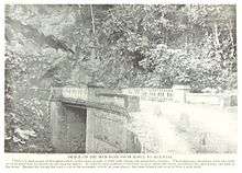
The construction of the first Ponce to Adjuntas road got underway through the dedicated efforts of local political leader, attorney, and composer Olimpio Otero in the late nineteenth century. In 1903, the Puerto Rico Legislature named a bridge on the Ponce to Adjuntas section of the road to his memory for his outstanding dedication to the building of that stretch of the road.[3] The bridge is located in the Magueyes barrio of the municipality of Ponce.
True to its farm-to-market purpose, PR-123 was designed to descend from the mountain town of Adjuntas and make its way through the Cordillera Central until it reached the city of Ponce, edging Plaza Las Delicias, located just two blocks from the Plaza del Mercado de Ponce fruits-and-vegetables central market place. The road then continued south, via Avenida Hostos, to the port of Ponce where coffee and other farm products were shipped to the United States and Europe. Under the Plan Ponce en Marcha, Avenida Hostos will be enlarged from two to four lanes.[5]
Prior to the construction of a new road (see PR-10) that took its number, the road was signed "PR-10".[6][7] This route signing for this old, winding road can still be seen in some old street maps of the city of Ponce.[8]
The stretch from Ponce to Adjuntas was built under the Spanish government. The remainder of the route to Arecibo was built after the Americans took over in 1898.[9] This second stretch opened on July 1, 1904. The whole course of the road from its southern end in Ponce to its northern end in Arecibo was signed as Road No. 6 in those days.[10]
Navigating this first PR-10 road was very tedious as the road was engineered to run from mountainside to mountainside, following the contours of the mountains, and along the natural definitions of the course of rivers, to reach its destination. Such design, however, limited considerably the speed of travel. It was also necessary to drive through the congested downtown areas of the various towns and villages in the way to get from one terminus of the road to the other, something that proved to be very time-consuming as vehicular traffic in those towns and villages increased. Despite these drawbacks, the road was heavily used for many decades. However, as traffic on this road increased in the 1950s and 1960s, the road started to show its limits.
The completed road had a length of 82 km.[11]
Characteristics
The road is prone to landslides and closings due to frequent heavy rains.[12]
References
- ↑ Guía de Carreteras Principales, Expresos y Autopistas. (In Spanish) Puerto Rico Autoridad de Carreteras y Transportacion (ACT).
- ↑ First Annual Register of Porto Rico, July, 1901. William H. Hunt, Secretary of Porto Rico. Puerto Rico Secretary's Office. July 1901. page 193. Accessed 20 February 2018.
- 1 2 A Resolution to Name and Designate "Otero Viaduct" a Certain Highway Bridge on the Section of the Arecibo-Ponce Road within the Municipality of Ponce. Acts of the Legislature of Puerto Rico. Approved 12 March 1903. By the Legislative Assembly of Puerto Rico. pp. 149-150. Retrieved 11 April 2010.
- ↑ Elements to Bear in Mind about Ponce Architecture. Jorge Ortiz Colom. Instituto de Cultura Puertorriqueña, Ponce Office. November 2007. Page 8. Accessed 20 March 2018.
- ↑ Carmelo Rosario Natal. Ponce En Su Historia Moderna: 1945-2002. Published by Secretaría de Cultura y Turismo of the Government of the Autonomous Municipality of Ponce. Ponce, Puerto Rico. 2003. p. 298.
- ↑ Avanza Construccion del Anillo de Circunvalacion. Amado Vega Velazquez. Periodico El Señorial. Government of the Municipality of Ponce, Puerto Rico. Año 2014. Edicion Especial. May 2014. page 3. Retrieved 13 August 2014.
- ↑ Neysa Rodriguez Deynes, Rafael J. Torres Torres, and Carlos Aneiro Perez. Brevario Sobre la Historia de Ponce y sus Principales Lugares de Interes. Published by Secretaría de Cultura y Turismo of the Government of the Autonomous Municipality of Ponce. Ponce, Puerto Rico. 1st edition. 1991. p. 143.
- ↑ Ponce Topographic Map. Map Styles: Map and Shaded. Trails.com. From: United States Geological Survey. Topo Map. Projection: NAD83/WGS84. Retrieved 20 September 2010.
- ↑ The Commercial Guide and Business Directory of Porto Rico. New York: F.E. Platt, publisher. June 10, 1910. pp. 287-288. Accessed 16 November 2010.
- ↑ Annual report of the Secretary of War. United States War Department. 1915. p. 280.
- ↑ "La Carretera Central: Su Historia." Progreso en la Construccion de Carreteras en Puerto Rico. (Table) Juan E. Castillo. Revista de Obras Publicas de Puerto Rico (Puerto Rico Public Works Journal). Year VII. Number 4. (April 1930) p.100. Accessed 8 February 2018.
- ↑ Guaraguao: al ras de la desesperación. Jason Rodríguez Grafal. La Perla del Sur. Ponce, Puerto Rico. Year 30. Issue 1479. Page 12. 4 April 2012. Retrieved 4 April 2012.
External links
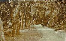
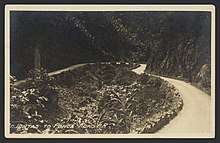
- Arecibo-Ponce Road c. 1930
- The Ponce-Adjuntas Road c. 1940s–1950s
- Juana Matos Bridge in Barrio Magueyes, Ponce, Puerto Rico c. 1908
- Another view of the Juana Matos Bridge on the Ponce-Adjuntas Road in Barrio Magueyes, Ponce, Puerto Rico c. 1908
- Abandoned Bus Stop at the intersection of PR-123 and PR-524 in Barrio Pellejas, Adjuntas