Prut
| Prut River | |
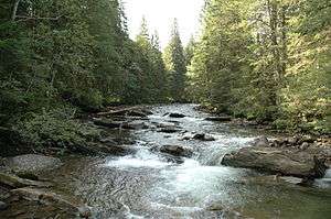 Prut River near Hoverla, Ivano-Frankivsk Oblast | |
| Countries | Ukraine, Romania, Moldova |
|---|---|
| Oblasts/ Counties/ Districts |
Ukraine: Ivano-Frankivsk O., Chernivtsi O. Romania: Botoșani C., Iași C., Vaslui C., Galați C. Moldova Briceni d., Edineț d., Rîșcani d., Glodeni d., Fălești d., Ungheni d., Nisporeni d., Hîncești d., Leova d., Cantemir d., Cahul d. |
| Tributaries | |
| - right | Cheremosh, Jijia |
| Cities | Kolomyia, Chernivtsi, Ungheni, Leova, Cahul |
| Source | Carpathian Mountains |
| - location | Mt. Hoverla, Ivano-Frankivsk O., Ukraine |
| Mouth | Danube |
| - location | Giurgiulești, Romania/Moldova |
| - coordinates | 45°28′8″N 28°12′28″E / 45.46889°N 28.20778°ECoordinates: 45°28′8″N 28°12′28″E / 45.46889°N 28.20778°E |
| Length | 953 km (592 mi) |
| Basin | 27,500 km2 (10,618 sq mi) |
| Discharge | |
| - average | 110 m3/s (3,885 cu ft/s) |
| Progression | Danube→ Black Sea |
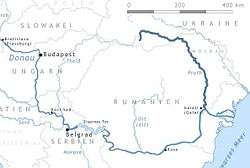 Map of the Prut River | |
The Prut (also spelled in English as Pruth; Romanian pronunciation: [prut], Ukrainian: Прут) is a 953 km (592 mi) long river in Eastern Europe. In part of its course it forms Romania's border with Moldova and Ukraine.
Overview
The Pruth was known in antiquity as the Pyretus (Ancient Greek Πυρετός), Porata (possibly),[1] Hierasus (Ιερασός) or Gerasius.[2] It originates on the eastern slope of Mount Hoverla, in the Carpathian Mountains in Ukraine. The Prut flows southeast, eventually joining the Danube river near Giurgiulești, east of Galați.
Between 1918 and 1939, the river was partly in Poland and partly in Greater Romania (Romanian: România Mare). Prior to World War I, it served as a border between Romania and the Russian Empire. After World War II, the river once again demarcated a border, this time between Romania and the Soviet Union. Nowadays, for a length of 695 km, it forms the border between Romania and Moldova. It has a hydrographic basin of 27,500 km2, of which 10,990 km2 are in Romania and 7,790 km2 in Moldova. The largest city along its banks is Chernivtsi, Ukraine.
The Stânca-Costești Dam, operated jointly by Moldova and Romania, is built on the Pruth. There is also a Hydro-Electric Station in Snyatyn, (Ukraine). Ships travel from the river's mouth to the port city of Leova (southern Moldova).
Description
Takes a start from a spring on the slopes of Hoverla, flows into the Danube near the village of Giurgiulesti (Moldova). Prigirlovaya part of the basin is strongly marshy. The length of 967 km (in the territory of Ukraine - 272 km), the area of the basin - 27,5 thousand km². Average water consumption at the city of Leova is 69.2 m³ / s. The slope of the river varies from 100 m / km (near the source) to 0.05 m / km (near the mouth). In the upper reaches (to Delyatyn) it has a mountainous character, with a steep right bank, sometimes the cross-sectional profile of the channel has the form of a ridge. Near the city of Yaremche is the waterfall of Probiy. Spring floods, summer rain floods, high winter runoff (due to thawing and rains). Sliced from January to February until the beginning of March.
About the name
In the second volume of the Ottoman-Bulgarian chronicles of Iman "Jagfar Tarihi" (1680) the Prut River is referred to as Burat. And in the Byzantine treatise of Constantine Porphyrogennetos "On the management of the empire" it is mentioned as the Brut river (Chap. 38) or as Burat (Chapter 42).
Location
The Prut river basin on the hydrograph map of Ukraine The upper current in Ukraine (Ivano-Frankivsk and Chernivtsi region) is lower - on the border of Moldova with Romania. The origins are located on the Carpathian massif of Chornogora, near Mount Hoverli. The river flows primarily to the north, after (within the limits of Yaremche city) it returns to the northeast, closer to Kolomyia, to the south-east. Having reached the border between Moldova and Romania, it returns even more to the south-east, and then to the south. Falls into the Danube 3 km west of the city of Reni (Odesa region). The rod is navigable from the city of Leovo (Moldova). On the Prut is a reservoir of Kostešti-Stikka and HPP (partly within Romania). Sniatyn HPP is the only hydroelectric power plant on the Prut within Ukraine (see Small HPS of Ukraine). Cities: Yaremche, Kolomyia, Snyatin, Chernivtsi, Novoselytsia, Ungheni.
Towns
The following towns are situated along the river Prut, from source to mouth: Deliatyn, Lanchyn, Kolomyia, Sniatyn, Chernivtsi, Novoselytsia, Darabani, Lipcani, Ungheni, Leova, Cantemir and Cahul
Tributaries
The following rivers are tributaries to the river Prut (source to mouth):
Left: Turka, Chorniava, Sovytsia, Rokytna, Rynhach, Cherlena, Larga (Briceni), Vilia, Lopatnic, Racovăț, Ciuhur, Camenca, Delia, Nârnova, Lăpușna, Sărata, Larga (Cantemir)
Right: Pistynka, Rybnytsia, Cheremosh, Derelui, Herța, Poiana, Cornești, Isnovăț, Rădăuți, Ghireni, Volovăț, Badu, Bașeu, Corogea, Berza Veche, Râioasa, Soloneț, Cerchezoaia, Jijia, Cozmești, Bohotin, Moșna, Pruteț, Elan, Horincea, Oancea, Stoeneasa, Chineja
Historical events
During the Russo-Turkish War of 1710–1711, on 19 July 1711 Russian forces initially divided among Peter the Great's army on the west bank and Boris Sheremetev's army on the east bank of the Pruth and allied with Dimitrie Cantemir, the ruler of Moldova, met with the Ottoman army led by Grand Vizier Baltaci Mehmed Pasha. The Turks and Crimean Tatars attacked first against Sheremetev, who then retreated to the other side to join Peter the Great. Afterwards the Russian army set up a defensive camp between Stănilești (Stanileshti) and the river, which was then completely surrounded by the Ottoman army. Negotiations started on 21 July 1711 and the Treaty of the Prut was signed on 23 July 1711. After this treaty, Dimitrie Cantemir had to go in exile at Moscow. This treaty means the end of local dynasties of kings and inauguration of Greek rulers from the Fanar Qunarter of Istanbul (Phanariotes.
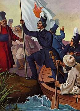
A bit more than a century later, in 1821, the Greek Nationalist leader Alexander Ypsilantis crossed the Prut river at Sculeni, with the intention of touching off a rebellion in the Danubian Principalities. Though the Wallachian uprising ultimately failed - due especially to irreconcilable differences between Ypsilantis and his Wallachian ally Tudor Vladimirescu - it did touch off the Greek War of Independence, leading to the Kingdom of Greece gaining independence ten years later. In the Principalities it led to the end of the aforementioned Greek Phanariote rule, and indirectly to increasing self-government and eventually to the independence of Romania several decades later. In Greek History, Ypsilantis' crossing of the Prut is an important historical event, commemorated in a famous painting displayed at Athens.
Popular culture
Sydir Vorobkevych: Within that Prut Valley (Над Прутом у лузі).[3]
Within that Prut Valley a cabin rests close
In which lives a lassie—a beautiful rose:
Her eyes like the bright stars that lighten the sky;
When you see them, laddie, you'll pause with a sigh.
Within that Prut Valley the moon does not shine,
'Tis only a lover has come to his shrine.
A sweet conversation in murmur now goes
While dreamy old river just quietly flows.
Within that Prut Valley the flowers are plucked
And wreathes for the wedding with myrtle are tucked;
Inside of the cabin play fiddles and bass
While friends sing together: To their Happiness!
Translated by Waldimir Semenyna (13 October 1933, Ukrainian Weekly).
Bridges
- Lipcani-Rădăuți Bridge
- Eiffel Bridge, Ungheni
- Costești-Stânca
- Fălciu-Cantemir
- Oancea-Cahul
- Galați-Giurgiulești
See also
Gallery
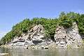 Skelia sphinx
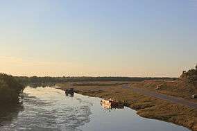 Prut near Giurgiulești, Cahul District
_bei_Jaremcze_(Jaremze)_von_Karl_Jeczmieniowski.jpg) Bridge over the Prut at Yaremche. Drawing by Karl Jeczmieniowski, 1893
Bridge over the Prut at Yaremche. Drawing by Karl Jeczmieniowski, 1893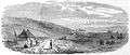 Banks of the Prut in a 1876 edition of The Illustrated London News
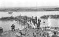 German engineers building a pontoon bridge across the Prut River during the advance towards Uman, 1941
 Prut at its beginning
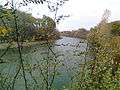
References
- ↑ Herodotus, translated by Thomas Gaisford and edited by Peter Edmund Laurent, The Nine Books of the History of Herodotus, Henry Slatter 1846, p. 299
- ↑ Peter Heather, The Goths, Blackwell Publishing, 1998, p. 100
- ↑ "1933" The Ukrainian Weekly 1933-02.pdf (in English)
- Administrația Națională Apelor Române - Cadastrul Apelor - București
- Institutul de Meteorologie și Hidrologie - Rîurile României - București 1971
External links
| Wikimedia Commons has media related to Prut River. |
- (in English) Prut River at the Encyclopedia of Ukraine
| Countries | 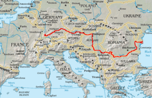 | |
|---|---|---|
| Cities | ||
| Tributaries | ||
| See also | ||