Providencia, Chile
| Providencia | |||||
|---|---|---|---|---|---|
| City and Commune | |||||
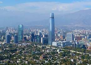 Financial district in Providencia. | |||||
| |||||
| Coordinates (city): 33°26′S 70°37′W / 33.433°S 70.617°WCoordinates: 33°26′S 70°37′W / 33.433°S 70.617°W | |||||
| Country | Chile | ||||
| Region | Santiago Metro. | ||||
| Province | Santiago | ||||
| Seat | 25 February 1897 | ||||
| Government[1] [2] | |||||
| • Type | Municipality | ||||
| • Alcaldesa | Evelyn Matthei Fornet (UDI) | ||||
| Area[3] | |||||
| • Total | 14.4 km2 (5.6 sq mi) | ||||
| Population (2002 Census)[3] | |||||
| • Total | 120,874 | ||||
| • Density | 8,400/km2 (22,000/sq mi) | ||||
| • Urban | 120,874 | ||||
| • Rural | 0 | ||||
| Sex[3] | |||||
| • Men | 53,082 | ||||
| • Women | 67,792 | ||||
| Time zone | UTC-4 (CLT [4]) | ||||
| • Summer (DST) | UTC-3 (CLST [5]) | ||||
| Postal Code | 7500000 | ||||
| Area code(s) | 56 + | ||||
| Website | Municipality of Providencia | ||||
.svg.png)


Providencia (Spanish pronunciation: [pɾoβiˈðensja], Spanish: "providence") is a commune of Chile located in Santiago Province, Santiago Metropolitan Region. Part of Greater Santiago, it is bordered by the communes of Santiago to the west, Recoleta to the northwest, Las Condes and Vitacura to the northeast, La Reina to the east, and Ñuñoa to the south.
Providencia is home to a large upper middle to upper-class population and it holds the region's highest percentage of population over 60 (22%). It contains many high-rise apartment buildings as well as a significant portion of Santiago's commerce. It is notable for its large, old and elegant houses inhabited in the past by the Santiago elite and now mostly used as offices. The municipality is also home to many embassies, including those of Poland, Italy, France, Egypt, Russia, Japan, China, and Uruguay.
Demographics
According to the 2002 census of the National Statistics Institute, Providencia spans an area of 14.4 km2 (6 sq mi) and has 120,874 inhabitants (53,082 men and 67,792 women), making the commune an entirely urban area. The population grew by 8.7% (9,692 persons) between the 1992 and 2002 censuses.[3]
Indicators
Notable residents
- Patricio Aylwin, former president
- Ricardo Lagos, former president
- Gabriel Valdés, former senator
Administration
As a commune, Providencia is a third-level administrative division of Chile administered by a municipal council, headed by an alcalde who is directly elected every four years. The 2016-2020 alcaldesa is Evelyn Matthei (UDI). The communal council has the following members:
- Manuel José Monckeberg (RN)
- Pilar Cruz Hurtado (RN)
- Iván Noguera Phillips (UDI)
- Pedro Lizana Greve (IND)
- Juan Carlos Labbé Reyes (IND)
- Pilar Fernández Valbuena (UDI)
- Pablo Jaeger Cousiño (PDC)
- Jaime Parada Hoyl (PRO)
- Julio Jung del Favero (PS)
- Tomás Echiburu Altamirano (RD)
Providencia is represented in the Chamber of Deputies by Maya Fernández (PS) and Marcela Sabat (RN) as part of the 21st electoral district (together with Ñuñoa). The commune is represented in the Senate by Carlos Montes (PS) and Manuel José Ossandón (RN) as part of the 8th senatorial constituency (Santiago-East).
The Directorate General of Civil Aviation has its headquarters in Providencia.[9]
Areas of interest
Providencia includes Barrio Suecia, an area filled with pubs and nightclubs, and Barrio Bellavista, a bohemian area populated with artists and performers. The latter lies in the shadow of Cerro San Cristóbal, a prominent hill in the city topped by a 22 m statue of The Virgin Mary. The north of Providencia is its financial and commercial district (centred on Providencia and Nueva Providencia (Ex 11 de Septiembre) avenues), while the remainder of it contains high-priced residential development.
Other notable areas of interest in Providencia include the Metropolitan Zoo, the Teleférico (an aerial gondola (closed since 2011 with no plans to re-open currently open in January 2017) that transported people from the foot of Pedro de Valdivia Norte Street to the top of San Cristóbal Hill), several television networks and Radio Cooperativa.
References
- ↑ "Asociación Chilena de Municipalidades" (in Spanish). Archived from the original on 19 April 2011. Retrieved 27 January 2011.
- ↑ "Municipality of Providencia" (in Spanish). Retrieved 27 January 2011.
- 1 2 3 4 "National Statistics Institute" (in Spanish). Retrieved 13 December 2010.
- ↑ "Chile Time". WorldTimeZones.org. Archived from the original on 13 July 2010. Retrieved 26 September 2010.
- ↑ "Chile Summer Time". WorldTimeZones.org. Archived from the original on 11 September 2007. Retrieved 26 September 2010.
- 1 2 3 Sistema de Información Regional, Ministry of Planning of Chile. Archived April 23, 2008, at the Wayback Machine.
- ↑ "Poverty in the Santiago Metropolitan Region" (PDF). Ministry of Planning of Chile (in Spanish). Archived from the original (PDF) on August 24, 2007.
- ↑ "Las Trayectorias del Desarrollo Humano en las Comunas de Chile (1994-2003) Archived 2011-07-07 at the Wayback Machine.." UNDP, Gobierno de Chile, Mideplán
- ↑ "Portada Archived 2012-04-16 at the Wayback Machine.." Directorate General of Civil Aviation. Retrieved on April 12, 2012. "Dirección General de Aeronáutica Civil, DGAC : Miguel Claro 1314, Providencia, Santiago de Chile :: Clasificador 3, Correo 9"
External links

- (in Spanish) Municipality of Providencia