Promontory Point, Utah

Promontory Peninsula with the Lucin Cutoff crossing the end of the peninsula
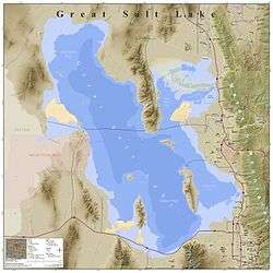
Promontory Point is the cape or southernmost point of the peninsula formed where the Promontory Mountains project into the northern Great Salt Lake at 41°12′18″N 112°25′43″W / 41.20500°N 112.42861°W in Box Elder County, Utah, with an elevation of 4,297 feet (1,310 m) above sea level.[1][2] It is 4.75 kilometres (2.95 mi) northwest of the west end of Fremont Island in Weber County.[2]
Promontory Point also refers to the location 41°13′20″N 112°24′38″W / 41.22222°N 112.41056°W[3] where the Lucin Cutoff intersects the east coast of the peninsula, 1.7 miles (2.7 km) northeast of the cape. The cutoff passes 1,250 feet (380 m) north of the cape and continues west 6.4 miles (10.3 km) to Saline, where the cutoff leaves the peninsula.[2]
See also
- Promontory Summit (Promontory, Utah) — pass at the north end of the Promontory mountains where the First Transcontinental Railroad was completed
References
- ↑ "Promontory Point (cape)". Geographic Names Information System. United States Geological Survey.
- 1 2 3 Promontory Point, Utah, 7.5 Minute Quadrangle, USGS, 1991
- ↑ "Promontory Point (locale)". Geographic Names Information System. United States Geological Survey.
This article is issued from
Wikipedia.
The text is licensed under Creative Commons - Attribution - Sharealike.
Additional terms may apply for the media files.