Wustermark
| Wustermark | ||
|---|---|---|
| ||
 Wustermark Location of Wustermark within Havelland district 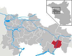 | ||
| Coordinates: 52°32′59″N 12°56′59″E / 52.54972°N 12.94972°ECoordinates: 52°32′59″N 12°56′59″E / 52.54972°N 12.94972°E | ||
| Country | Germany | |
| State | Brandenburg | |
| District | Havelland | |
| Government | ||
| • Mayor | Holger Schreiber (Ind.) | |
| Area | ||
| • Total | 52.63 km2 (20.32 sq mi) | |
| Elevation | 35 m (115 ft) | |
| Population (2017-12-31)[1] | ||
| • Total | 9,144 | |
| • Density | 170/km2 (450/sq mi) | |
| Time zone | CET/CEST (UTC+1/+2) | |
| Postal codes | 14641 | |
| Dialling codes | 033234 | |
| Vehicle registration | HVL | |
| Website | www.wustermark.de | |

Wustermark is a municipality of the Havelland district, in Brandenburg, Germany.
History
It was established in 2002 through a merger of the five villages Buchow-Karpzow, Elstal, Hoppenrade, Priort and Wustermark.
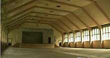
Interior of the dining hall for the 1936 Summer Olympics, unrestored as of 2012.
Near Elstal are the remains of the Olympic Village of the 1936 Summer Olympics in Berlin.
Demography
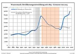 Development of Population since 1875 within the Current Boundaries (Blue Line: Population; Dotted Line: Comparison to Population Development of Brandenburg state; Grey Background: Time of Nazi rule; Red Background: Time of Communist rule)
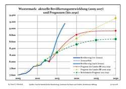 Recent Population Development and Projections (Population Development before Census 2011 (blue line); Recent Population Development according to the Census in Germany in 2011 (blue bordered line); Projection by the Brandenburg state for 2005-2030 (yellow line); Projection by the Brandenburg state for 2014-2030 (red line); Projection by the Bertelsmann Foundation for 2012-2030 (green line)
| Wustermark: Population development within the current boundaries (2017)[2] | ||||||||||||||||||||||||||||||||||||||||||||||||||||||||||||||||||||||||||||||||||||||||||||||||||||||||||||||||||||||||||||||||||||||
|---|---|---|---|---|---|---|---|---|---|---|---|---|---|---|---|---|---|---|---|---|---|---|---|---|---|---|---|---|---|---|---|---|---|---|---|---|---|---|---|---|---|---|---|---|---|---|---|---|---|---|---|---|---|---|---|---|---|---|---|---|---|---|---|---|---|---|---|---|---|---|---|---|---|---|---|---|---|---|---|---|---|---|---|---|---|---|---|---|---|---|---|---|---|---|---|---|---|---|---|---|---|---|---|---|---|---|---|---|---|---|---|---|---|---|---|---|---|---|---|---|---|---|---|---|---|---|---|---|---|---|---|---|---|---|
|
|
| ||||||||||||||||||||||||||||||||||||||||||||||||||||||||||||||||||||||||||||||||||||||||||||||||||||||||||||||||||||||||||||||||||||
See also
References
- ↑ "Bevölkerung im Land Brandenburg nach amtsfreien Gemeinden, Ämtern und Gemeinden 31. Dezember 2017 (Fortgeschriebene amtliche Einwohnerzahlen auf Grundlage des Zensus 2011)". Amt für Statistik Berlin-Brandenburg (in German). 2018.
- ↑ Detailed data sources are to be found in the Wikimedia Commons.Population Projection Brandenburg at Wikimedia Commons
External links
![]()
Towns and municipalities in Havelland | ||
|---|---|---|
This article is issued from
Wikipedia.
The text is licensed under Creative Commons - Attribution - Sharealike.
Additional terms may apply for the media files.