Primošten
| Primošten | |
|---|---|
| Town | |
 | |
 Primošten Location of Primošten within Croatia | |
| Coordinates: 43°35′N 15°55′E / 43.583°N 15.917°E | |
| Country | Croatia |
| County | Šibenik-Knin County |
| Government | |
| • Mayor | Stipe Petrina |
| Area | |
| • Total | 92 km2 (35.5 sq mi) |
| Population (2011)[1] | |
| • Total | 2,828 |
| Time zone | UTC+1 (CET) |
| • Summer (DST) | UTC+2 (CEST) |
| Postal code | 22 202 |
| Area code(s) | 022 |
| Website |
www |
Primošten (pronounced [prǐmɔʃtɛn]; Italian: Capocesto) is a town in Croatia, and a part of the Šibenik-Knin County. It is situated in the south, between the cities of Šibenik and Trogir, on the Adriatic coast.
History
In the past, Primošten was situated on the islet close to the mainland. During the Turkish invasions in 1542 the islet was protected by the walls and towers and a draw bridge connected it to the mainland. When the Turks retreated, the draw bridge was replaced by the causeway and in 1564 the settlement was named Primošten after the Croatian verb primostiti (to bridge).
It is built on a hill and is dominated by the parish church of St. George which was built in 1485 and restored in 1760 close to the local graveyard from which a unique view spreads to the sea and the surroundings.
Heritage
Primošten is famous for its huge and beautiful vineyards. A photo of the vineyards of Primošten hung in the UN center in New York. Apart from its vineyards, Primošten is also known for the traditional donkey race that takes place there every summer. The largest beach in Primošten is called Raduča, and its smaller part, Mala Raduča, is voted one of the 10 most beautiful beaches in Croatia. The area's vineyards are currently under consideration to become a UNESCO World Heritage site.[2]
Culture and events
Manifestation called "Primoštenske užance" is held every year in the middle of the summer in Primošten. It is a traditional folklore festival where people from Primošten exhibit their cultural specificity and the former way of living in the village.[3]
Gallery
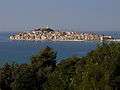 Primošten
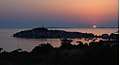 Sunset in Primošten
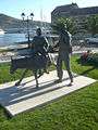
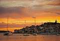 Sunset in Primošten
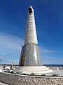 Our Lady of Loreto monument at Primošten
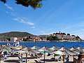 Beach at "Zora" Hotel
 Fountain in center of Primošten
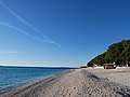 Beach in Primošten
Sport
- JK Primošten (sailing)
- MNK Primošten futsal
- RK Spongiola (diving)
- VK Primosten ( waterpolo)
- BK Primošten (cycling)
See also
References
- ↑ "Population by Age and Sex, by Settlements, 2011 Census: Primošten". Census of Population, Households and Dwellings 2011. Zagreb: Croatian Bureau of Statistics. December 2012.
- ↑ UNESCO - Primosten
- ↑ "Primosten - location, beaches, hotels and attractions". www.sibenik-croatia.com. Retrieved 2018-03-28.
External links
| Wikimedia Commons has media related to Primošten. |
- Official website
- Picture and video gallery
- Coast view at Dolac u Primoštenu. Part of Primošten municipality.
Subdivisions of Šibenik-Knin County | ||
|---|---|---|
| Cities and towns |  | |
| Municipalities | ||