Prespes
| Prespes Δήμος Πρεσπών | |
|---|---|
 Prespes municipality map | |
 Prespes Location within the region 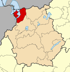 | |
| Coordinates: 40°45′N 21°8′E / 40.750°N 21.133°ECoordinates: 40°45′N 21°8′E / 40.750°N 21.133°E | |
| Country | Greece |
| Administrative region | West Macedonia |
| Regional unit | Florina |
| Area | |
| • Municipality | 515.5 km2 (199.0 sq mi) |
| • Municipal unit | 413.5 km2 (159.7 sq mi) |
| Population (2011)[1] | |
| • Municipality | 1,560 |
| • Municipality density | 3.0/km2 (7.8/sq mi) |
| • Municipal unit | 1,201 |
| • Municipal unit density | 2.9/km2 (7.5/sq mi) |
| Time zone | UTC+2 (EET) |
| • Summer (DST) | UTC+3 (EEST) |
| Postal code | 530 77 |
| Website | http://www.prespes.gr/ |
Prespes (Greek: Πρέσπες) is a municipality in the Florina regional unit, Greece. Population 1,560 (2011). The seat of the municipality is in Laimos.[2] It was named after Lake Prespa, in the western part of the municipality.
Municipality
The municipality Prespes was formed at the 2011 local government reform by the merger of the following 2 former municipalities, that became municipal units:[2]
- Krystallopigi
- Prespes
The municipality has an area of 515.497 km2, the municipal unit 413.513 km2.[3] According to the 2011 Greek census, Prespes was the least densely populated municipality in the country, with an average of 3.05 residents per square kilometre. [4]
Books
- ΠΡΕΣΠΑ η Ελληνική Δημήτρις Πένης
References
- ↑ "Απογραφή Πληθυσμού - Κατοικιών 2011. ΜΟΝΙΜΟΣ Πληθυσμός" (in Greek). Hellenic Statistical Authority.
- 1 2 Kallikratis law Greece Ministry of Interior (in Greek)
- ↑ "Population & housing census 2001 (incl. area and average elevation)" (PDF) (in Greek). National Statistical Service of Greece.
- ↑ http://greece.greekreporter.com/2011/07/25/results-for-greeces-population-are-out/. Missing or empty
|title=(help)
Administrative division of the Western Macedonia Region | ||
|---|---|---|
| Regional unit of Florina | 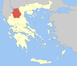 | |
| Regional unit of Grevena | ||
| Regional unit of Kastoria | ||
| Regional unit of Kozani | ||
| ||
This article is issued from
Wikipedia.
The text is licensed under Creative Commons - Attribution - Sharealike.
Additional terms may apply for the media files.