President Head
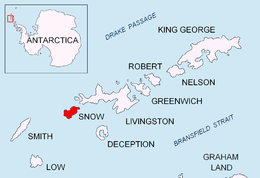

President Head (62°43′34.7″S 61°12′05.8″W / 62.726306°S 61.201611°WCoordinates: 62°43′34.7″S 61°12′05.8″W / 62.726306°S 61.201611°W) is a headland forming the east extremity of Snow Island, in the South Shetland Islands, Antarctica. Extending 2.6 km in east-northeast direction, rising to 107 m at St. Sofroniy Knoll. Adjacent ice-free area ca. 303 hectares (750 acres).[1]
The name "President Island" was applied by the Stonington sealers in 1820-21 to Snow Island, but that name did not become established. "President Head" was applied by the United Kingdom Antarctic Place-Names Committee (UK-APC) in 1961 in order to preserve the name on this island.
Maps
- L.L. Ivanov et al. Antarctica: Livingston Island and Greenwich Island, South Shetland Islands. Scale 1:100000 topographic map. Sofia: Antarctic Place-names Commission of Bulgaria, 2005.
Notes
- ↑ L.L. Ivanov. Antarctica: Livingston Island and Greenwich, Robert, Snow and Smith Islands. Scale 1:120000 topographic map. Troyan: Manfred Wörner Foundation, 2009. ISBN 978-954-92032-6-4
References
![]()