Prague 11
| Prague 11 (Praha 11) | |||
| Municipal District of Prague Administrative District of Prague | |||
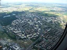 Aerial view of Jižní Město | |||
|
|||
| Official name: Městská část Praha 11 | |||
| Country | Czech Republic | ||
|---|---|---|---|
| Region | Prague | ||
| Coordinates | 50°1′43″N 14°31′54″E / 50.02861°N 14.53167°ECoordinates: 50°1′43″N 14°31′54″E / 50.02861°N 14.53167°E | ||
| Area | 9.80 km2 (4 sq mi) | ||
| Population | 78,519 (2008) | ||
| Density | 8,012/km2 (20,751/sq mi) | ||
| Mayor | Dalibor Mlejnský | ||
| Timezone | CET (UTC+1) | ||
| - summer (DST) | CEST (UTC+2) | ||
| Postal code | 148 00, 149 00 | ||
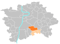 Location of Prague 11 in Prague | |||
| Website: http://www.praha11.cz/en/ | |||


Prague 11 is a municipal district (městská část) in Prague, Czech Republic. It is located in the south eastern part, 8 km from the City Center.
The district is split into two parts, mainly from the perspective of pedestrians, by the south-eastern highway to Brno. Praha 11 comprises Chodov, Opatov and Háje on one side and Roztyly on the other side.
Praha 11 is mostly residential district because of the huge panel housing estate called Jižní Město. At the beginning of 2016, it had 77,175 inhabitants.[1] With the city centre it is connected by metro line C.
The administrative district (správní obvod) of the same name consists of municipal districts Prague 11, Křeslice, Šeberov and Újezd.
References
- ↑ "Obyvatelstvo Prahy podle městských částí 1991–2015". Český statistický úřad. Retrieved 8 January 2018.
External links
- Prague 11 - Official homepage, praha11.cz
- plan, praha11.cz
This article is issued from
Wikipedia.
The text is licensed under Creative Commons - Attribution - Sharealike.
Additional terms may apply for the media files.