Koloděje
| Koloděje (Koloděje) | |||
| Municipal District of Prague Cadastral Area of Prague | |||
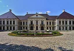 chateau in Koloděje | |||
|
|||
| Official name: Městská část Praha-Koloděje | |||
| Country | Czech Republic | ||
|---|---|---|---|
| Region | Prague | ||
| District | Prague 21 | ||
| Coordinates | 50°3′47″N 14°38′27″E / 50.06306°N 14.64083°ECoordinates: 50°3′47″N 14°38′27″E / 50.06306°N 14.64083°E | ||
| Area | 3.74 km2 (1 sq mi) | ||
| Population | 1,206 (2008) | ||
| Density | 322/km2 (834/sq mi) | ||
| Mayor | Zdeněk Kovář | ||
| Timezone | CET (UTC+1) | ||
| - summer (DST) | CEST (UTC+2) | ||
| Postal code | 190 16 | ||
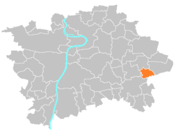 Location of Kolodějein Prague | |||
| Website: http://www.kolodejepraha.wz.cz | |||
Koloděje is a municipal district (městská část) and cadastral area (katastrální území) in Prague. It is located in the eastern part of the city. As of 2008, there were 1206 inhabitants living in Koloděje.
The first written record of Koloděje is from the 13th century. The village became part of Prague in 1974.
External links
| Wikimedia Commons has media related to Koloděje. |
This article is issued from
Wikipedia.
The text is licensed under Creative Commons - Attribution - Sharealike.
Additional terms may apply for the media files.