Prague 10
| Prague 10 (Praha 10) | |||
| Municipal District of Prague Administrative District of Prague | |||
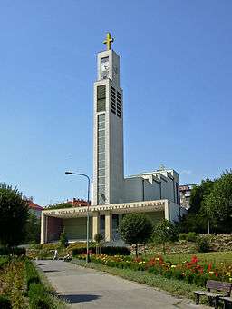 Saint Wenceslaus Church in Vršovice | |||
|
|||
| Official name: Městská část Praha 10 | |||
| Country | Czech Republic | ||
|---|---|---|---|
| Region | Prague | ||
| Coordinates | 50°4′18″N 14°29′53″E / 50.07167°N 14.49806°ECoordinates: 50°4′18″N 14°29′53″E / 50.07167°N 14.49806°E | ||
| Highest point | Bohdalec | ||
| - elevation | 273 m (896 ft) | ||
| - coordinates | 50°3′36″N 14°27′56″E / 50.06000°N 14.46556°E | ||
| Area | 18.60 km2 (7 sq mi) | ||
| Population | 111,685 (2008) | ||
| Density | 6,005/km2 (15,553/sq mi) | ||
| Founded | 1990 | ||
| Mayor | Ing. Vladimír Novák | ||
| Timezone | CET (UTC+1) | ||
| - summer (DST) | CEST (UTC+2) | ||
| Postal code | 100 00 | ||
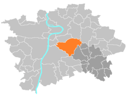 Location of Prague 10 in Prague | |||
| Website: http://www.praha10.cz | |||


Prague 10 is both a municipal and administrative district in Prague, Czech Republic with more than 100,000 inhabitants.
Neighbourhood (cadastral communities) of Prague 10
- Vršovice
- large part of Strašnice (except the block with Tesla Strašnice and part of Nákladové nádraží Žižkov, which fall within the city district Prague 3)
- small part of Vinohrady (south and east from the streets Slovenská, U vodárny, Korunní, Šrobárova, U vinohradského hřbitova a Vinohradská)
- large part of Malešice
- part of Záběhlice
- part of Michle (Bohdalec and the greater part of the Slatiny settlement)
- small part of Žižkov
- other small parts
Important Buildings
References
External links
This article is issued from
Wikipedia.
The text is licensed under Creative Commons - Attribution - Sharealike.
Additional terms may apply for the media files.