Posadas, Misiones
| Posadas | |||
|---|---|---|---|
| City | |||
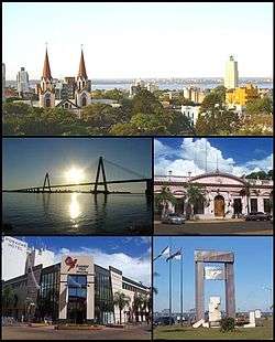 (From top to bottom; from left to right) Panoramic view of the city; San Roque Bridge; Misiones Government House; Posadas Plaza Shopping and Monument to Malvinas. | |||
| |||
 Posadas Location of Posadas in Argentina | |||
| Coordinates: 27°22′S 55°54′W / 27.367°S 55.900°WCoordinates: 27°22′S 55°54′W / 27.367°S 55.900°W | |||
| Country |
| ||
| Province |
| ||
| Department | Capital | ||
| Founded | 1870 | ||
| Government | |||
| • Mayor | Joaquín Losada (Frente Renovador) | ||
| Elevation | 120 m (390 ft) | ||
| Population (2010 census) | |||
| • Urban | 275,028 | ||
| • Metro | 319,000 | ||
| Time zone | UTC−3 (ART) | ||
| CPA base | N3300 | ||
| Dialing code | +54 376 | ||
| Website | Official website | ||
.svg.png)

Posadas (Spanish pronunciation: [poˈsaðas]) is the capital city of the Argentine province of Misiones, in its south, at the far north-east of the country on the left bank of the Paraná River, opposite Encarnación, Paraguay. The city has an area of 965 square kilometres (373 sq mi) and a population of 324,756, and the Greater Posadas area has a population of over 351,000 (2010 census [INDEC]).
Posadas is the provincial centre of the government, culture and the economy. Furniture, tobacco, food, textiles and construction are its most important industries. Other important economical activities are commerce and services.
Posadas is connected to the Paraguayan city of Encarnación by the San Roque González de Santa Cruz Bridge. The port, once of great economical importance, is used for sport vessels, carrier of passengers and some boats for sand transport. The city is located on National Route 12, some 1,300 kilometres (810 mi) from Buenos Aires. The General José de San Martín Airport (IATA: PSS, ICAO: SARP), at coordinates 27°22′S 55°58′W / 27.367°S 55.967°W, is seven kilometres from the city, and features regular flights to Buenos Aires.
History
Father Roque González y de Santa Cruz established a town called Anunciación de Itapúa on March 25, 1615, but ten years later the settlement was moved to the other side of the Paraná River to the present location of Encarnación, Paraguay.
The first settlement was not completely abandoned, and a new San José reduction was settled there in 1628. In 1867, during the Paraguayan War, the Brazilians set up the Trinchera de San José military base there. Following the end of the war, Paraguay renounced all claims to the area, and in 1879, the town was renamed after Gervasio Antonio de Posadas, the Supreme Director of the Argentine Confederation (1814).
On December 22, 1881, the limits of the Misiones Federation were drawn, leaving Posadas within the territory of current Corrientes Province. On July 30, 1884 the National Congress decided to give Posadas to Misiones Province, and name it its capital. The National University of Misiones was established at Posadas in 1973, and in 1990, the city's cultural and economic links to Encarnación were strengthened with the completion of the San Roque González de Santa Cruz Bridge.
Public transportation
The average amount of time people spend commuting with public transit in Posadas, for example to and from work, on a weekday is 57 min. 10% of public transit riders, ride for more than 2 hours every day. The average amount of time people wait at a stop or station for public transit is 16 min, while 26% of riders wait for over 20 minutes on average every day. The average distance people usually ride in a single trip with public transit is 4.3 km, while 2% travel for over 12 km in a single direction. [1]
Climate
| Posadas | ||||||||||||||||||||||||||||||||||||||||||||||||||||||||||||
|---|---|---|---|---|---|---|---|---|---|---|---|---|---|---|---|---|---|---|---|---|---|---|---|---|---|---|---|---|---|---|---|---|---|---|---|---|---|---|---|---|---|---|---|---|---|---|---|---|---|---|---|---|---|---|---|---|---|---|---|---|
| Climate chart (explanation) | ||||||||||||||||||||||||||||||||||||||||||||||||||||||||||||
| ||||||||||||||||||||||||||||||||||||||||||||||||||||||||||||
| ||||||||||||||||||||||||||||||||||||||||||||||||||||||||||||
Posadas has a humid subtropical climate (Köppen Cfa). Summers are hot and humid with lows around 21 °C (69.8 °F), highs around 31.5 °C (88.7 °F), daily mean 26.0 °C (78.8 °F), and frequent thunderstorms. Winters are warm with lows around 12 °C (53.6 °F) and highs around 22.5 °C (72.5 °F), daily mean 17 °C (62.6 °F) . The highest temperature ever recorded was 42.1 °C (107.8 °F) and the coldest was −2.8 °C (27.0 °F).[2]
| Climate data for Posadas Airport (1981–2010, extremes 1961–present) | |||||||||||||
|---|---|---|---|---|---|---|---|---|---|---|---|---|---|
| Month | Jan | Feb | Mar | Apr | May | Jun | Jul | Aug | Sep | Oct | Nov | Dec | Year |
| Record high °C (°F) | 41.2 (106.2) |
39.8 (103.6) |
39.5 (103.1) |
36.2 (97.2) |
34.0 (93.2) |
31.0 (87.8) |
33.0 (91.4) |
38.2 (100.8) |
37.2 (99) |
38.3 (100.9) |
41.7 (107.1) |
42.1 (107.8) |
42.1 (107.8) |
| Average high °C (°F) | 33.0 (91.4) |
32.1 (89.8) |
31.2 (88.2) |
27.6 (81.7) |
23.9 (75) |
21.9 (71.4) |
21.9 (71.4) |
24.2 (75.6) |
25.1 (77.2) |
28.3 (82.9) |
30.3 (86.5) |
32.4 (90.3) |
27.7 (81.9) |
| Daily mean °C (°F) | 27.0 (80.6) |
26.2 (79.2) |
25.1 (77.2) |
21.9 (71.4) |
18.3 (64.9) |
16.5 (61.7) |
16.1 (61) |
17.9 (64.2) |
19.2 (66.6) |
22.3 (72.1) |
24.2 (75.6) |
26.3 (79.3) |
21.8 (71.2) |
| Average low °C (°F) | 21.8 (71.2) |
21.3 (70.3) |
20.2 (68.4) |
17.4 (63.3) |
14.0 (57.2) |
12.3 (54.1) |
11.6 (52.9) |
13.1 (55.6) |
14.3 (57.7) |
17.1 (62.8) |
18.6 (65.5) |
20.7 (69.3) |
16.9 (62.4) |
| Record low °C (°F) | 10.5 (50.9) |
10.3 (50.5) |
5.7 (42.3) |
4.3 (39.7) |
0.6 (33.1) |
−1.5 (29.3) |
−2.8 (27) |
−1.8 (28.8) |
1.3 (34.3) |
4.8 (40.6) |
6.9 (44.4) |
9.6 (49.3) |
−2.8 (27) |
| Average precipitation mm (inches) | 167.2 (6.583) |
154.9 (6.098) |
144.1 (5.673) |
193.8 (7.63) |
138.2 (5.441) |
139.8 (5.504) |
103.3 (4.067) |
93.9 (3.697) |
145.1 (5.713) |
226.0 (8.898) |
181.0 (7.126) |
179.9 (7.083) |
1,867.2 (73.512) |
| Average precipitation days (≥ 0.1 mm) | 10.3 | 9.6 | 9.0 | 10.2 | 8.3 | 9.4 | 9.0 | 8.3 | 10.9 | 11.3 | 9.5 | 9.4 | 115.2 |
| Average relative humidity (%) | 68.5 | 72.1 | 73.0 | 76.4 | 77.4 | 78.8 | 74.7 | 70.3 | 69.8 | 69.8 | 66.9 | 65.8 | 72.0 |
| Mean monthly sunshine hours | 248.0 | 214.7 | 170.5 | 195.0 | 186.0 | 144.0 | 158.1 | 161.2 | 111.0 | 201.5 | 219.0 | 232.5 | 2,241.5 |
| Percent possible sunshine | 59 | 58 | 45 | 57 | 55 | 46 | 48 | 46 | 31 | 50 | 54 | 54 | 50 |
| Source #1: Servicio Meteorológico Nacional[3][4] | |||||||||||||
| Source #2: UNLP (sun only)[5] | |||||||||||||
Notable people
- José Acasuso, tennis player
- Alberto Mancini, tennis player
- Mariano Messera, soccer player
- Daniel Vancsik, golf player
Sister cities
References
- ↑ "Posadas Public Transportation Statistics". Global Public Transit Index by Moovit. Retrieved June 19, 2017.

- ↑ "Datos Estadísticos (Período 1981-1990)" (in Spanish). National Meteorological Service of Argentina. Retrieved August 23, 2012.
- ↑ "Estadísticas Climatológicas Normales - período 1981-2010" (in Spanish). Servicio Meteorológico Nacional. Retrieved January 20, 2018.
- ↑ "Clima en la Argentina: Guia Climática por Posadas Aero". Caracterización: Estadísticas de largo plazo (in Spanish). Servicio Meteorológico Nacional. Archived from the original on 4 September 2017. Retrieved 4 October 2017.
- ↑ "Datos bioclimáticos de 173 localidades argentinas". Atlas Bioclimáticos (in Spanish). Universidad Nacional de La Plata. Retrieved April 8, 2014.
- ↑ "Posadas y sus hermanas" (in Spanish). Primera Edición. Archived from the original on 2015-04-02. Retrieved 2015-03-28.
External links
| Wikivoyage has a travel guide for Posadas. |
- (in Spanish) Municipality of Posadas - Official website.
- (in Spanish) Municipal information: Municipal Affairs Federal Institute (IFAM), Municipal Affairs Secretariat, Ministry of Interior, Argentina. (in Spanish)
- (in Spanish) Universidad Nacional de Misiones
- Posadas Information
| Champion drivers |
|
|---|---|
| Cars | |
| Current circuits (2012) | |
| Former circuits | |
| Authority control |
|---|